Image:Khazar map1.PNG
From Wikipedia, the free encyclopedia
Size of this preview: 640 × 403 pixels
Full resolution (939 × 592 pixels, file size: 336 KB, MIME type: image/png)
| |
This is a file from the Wikimedia Commons. The description on its description page there is shown below. |
Summary
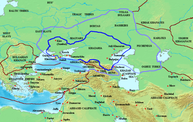
Map of the Khazar Khaganate and surrounding states, c. 820 CE. Area of direct Khazar control shown in dark blue, sphere of influence in purple. Other boundaries shown in dark red.
Made by User:Briangotts
Licensing
 |
Permission is granted to copy, distribute and/or modify this document under the terms of the GNU Free Documentation License, Version 1.2 or any later version published by the Free Software Foundation; with no Invariant Sections, no Front-Cover Texts, and no Back-Cover Texts. Subject to disclaimers. Asturianu | Български | Català | Deutsch | English | Español | Français | Gaeilge | Italiano | Polski | Português | +/- |
File history
Click on a date/time to view the file as it appeared at that time.
| Date/Time | Dimensions | User | Comment | |
|---|---|---|---|---|
| current | 15:20, 27 October 2006 | 939×592 (336 KB) | Frode Inge Helland | (== Summary == Map of the Khazar Khaganate and surrounding states, c. 820 CE. Area of direct Khazar control shown in dark blue, sphere of influence in purple. Other boundaries shown in dark red. Category:Historical maps by User:Briangotts == L) |
| 15:17, 27 October 2006 | 939×592 (336 KB) | Frode Inge Helland | (== Summary == Map of the Khazar Khaganate and surrounding states, c. 820 CE. Area of direct Khazar control shown in dark blue, sphere of influence in purple. Other boundaries shown in dark red. Category:Historical maps by User:Briangotts == L) |
File links
The following pages on Schools Wikipedia link to this image (list may be incomplete):