Image:Khazar0.png
From Wikipedia, the free encyclopedia
Size of this preview: 552 × 479 pixels
Full resolution (637 × 553 pixels, file size: 27 KB, MIME type: image/png)
| |
This is a file from the Wikimedia Commons. The description on its description page there is shown below. |
| Description |
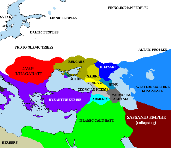
The en:Pontic steppe region, c. AD 650. en:Category:Historical maps by User:Briangotts
|
|---|---|
| Source |
Originally from en.wikipedia; description page is/was here. |
| Date |
2005-12-29 (first version); 2007-04-11 (last version) |
| Author |
Original uploader was Briangotts at en.wikipedia |
| Permission ( Reusing this image) |
Released under the GNU Free Documentation License.
|
License information
 |
Permission is granted to copy, distribute and/or modify this document under the terms of the GNU Free Documentation license, Version 1.2 or any later version published by the Free Software Foundation; with no Invariant Sections, no Front-Cover Texts, and no Back-Cover Texts. A copy of the license is included in the section entitled " GNU Free Documentation license". Aragonés | العربية | Asturianu | Беларуская (тарашкевіца) | Български | বাংলা | ইমার ঠার/বিষ্ণুপ্রিয়া মণিপুরী | Brezhoneg | Bosanski | Català | Cebuano | Česky | Dansk | Deutsch | Ελληνικά | English | Esperanto | Español | Eesti | Euskara | فارسی | Suomi | Français | Gaeilge | Galego | עברית | Hrvatski | Magyar | Bahasa Indonesia | Ido | Íslenska | Italiano | 日本語 | ქართული | ភាសាខ្មែរ | 한국어 | Kurdî / كوردی | Latina | Lëtzebuergesch | Lietuvių | Bahasa Melayu | Nnapulitano | Nederlands | Norsk (nynorsk) | Norsk (bokmål) | Occitan | Polski | Português | Română | Русский | Slovenčina | Slovenščina | Shqip | Српски / Srpski | Svenska | తెలుగు | ไทย | Tagalog | Türkçe | Українська | اردو | Tiếng Việt | Volapük | Yorùbá | 中文(简体) | 中文(繁體) | +/- |
Original upload log
(All user names refer to en.wikipedia)
- 2007-04-11 19:01 Briangotts 637×553×8 (27154 bytes) == Summary == The [[Pontic steppe]] region, c. AD 650. [[Category:Historical maps by User:Briangotts]] [[Category:Maps of the history of Russia]]
- 2006-01-24 17:57 Briangotts 406×448×8 (15464 bytes) == Summary == The [[Pontic steppe]] region, c. 650 CE. [[Category:Historical maps by User:Briangotts]] == Licensing == {{GFDL-self}}
- 2005-12-29 20:33 Briangotts 406×448×8 (15489 bytes) == Summary == The [[Pontic steppe]] region, c. 650 CE. [[Category:Historical maps by User:Briangotts]] == Licensing == {{GFDL-self}}
- 2005-12-29 20:30 Briangotts 406×448×8 (15662 bytes) The [[Pontic steppe]] region, c. 650 CE. [[Category:Historical maps by User:Briangotts]]
File history
Click on a date/time to view the file as it appeared at that time.
| Date/Time | Dimensions | User | Comment | |
|---|---|---|---|---|
| current | 10:43, 25 May 2007 | 637×553 (27 KB) | Angusmclellan | ({{Information |Description=The en:Pontic steppe region, c. AD 650. en:Category:Historical maps by User:Briangotts en:Category:Maps of the history of Russia |Source=Originally from [http://en.wikipedia.org en.wikipedia]; description page ) |
| 08:44, 17 January 2006 | 406×448 (15 KB) | Jrohr | (== Summary == The Pontic steppe region, c. 650 CE. Category:Historical maps by User:Briangotts == Licensing == {{GFDL-self}} ) |