Image:Gibraltar map-en-edit2.svg
From Wikipedia, the free encyclopedia
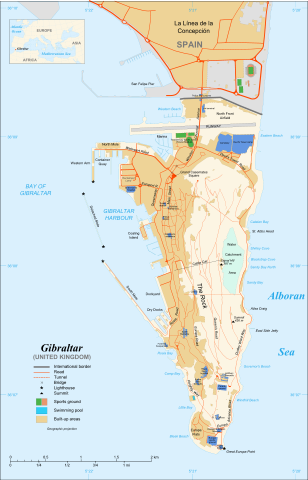
Gibraltar_map-en-edit2.svg (SVG file, nominally 1,000 × 1,558 pixels, file size: 1.79 MB)
| |
This is a file from the Wikimedia Commons. The description on its description page there is shown below. |
| This is a featured picture, which means that members of the community have identified it as one of the finest images on the English Wikipedia, adding significantly to its accompanying article. If you have a different image of similar quality, be sure to upload it using the proper free license tag, add it to a relevant article, and nominate it. |
| |
This image was selected as picture of the day on the English Wikipedia for September 10, 2008. |
| |
This is a featured picture on English Wikipedia and is considered one of the finest images.
|
|
| |
This vector image was created with Inkscape. |
| Camera location |
36°08′00″N, 5°21′00″W |
This and other geocoded Commons images: |
( Info) |
|---|
| Description |
Map in English of Gibraltar |
|---|---|
| Source |
adapted from: Image:Gibraltar map-en.svg |
| Date |
November 2007 |
| Author |
Original by Eric Gaba ( Sting), label/legend edits by Jeff Dahl |
| Permission ( Reusing this image) |
Attribution and Share-Alike required |
| Other versions | Español, Français |
- Sujet : Carte en anglais de Gibraltar ;
- Sources : Création personnelle ;
-
- Carte créée à partir de captures d'écran d'images satellite de Google Earth d'un point de vue placé à 1,18 km d'altitude (imagerie disponible de novembre 2007) ;
- Références complémentaires :
-
- Carte du Ministère de la Défense britannique ;
- Carte de localisation : Image:Blank_map_of_South_Europe_and_North_Africa.svg (modifiée) crée par Historicair ;
- Échelle approximative : 1:40 000 (précision : environ 10 m) ;
- Note : Largeur du tracé des routes proportionnelle à la réalité ;
- Auteur : Eric Gaba ( fr:Sting) ;
- Date : Novembre 2007.
 |
This SVG file uses embedded text that can be easily translated into your language. Learn more. For SVG images, you can use this page to translate it into your language. العربية | Català | Dansk | Deutsch | English | Esperanto | Español | Français | Galego | Italiano | 日本語 | Lietuvių | Magyar | Nederlands | Polski | Português | Русский | Svenska | Українська | +/- |
Licensing
|

File history
Click on a date/time to view the file as it appeared at that time.
| Date/Time | Dimensions | User | Comment | |
|---|---|---|---|---|
| current | 18:52, 11 December 2007 | 1,000×1,558 (1.79 MB) | Jeff Dahl | (resized 1200 down to 1000px wide, minor label fixes) |
| 17:08, 10 December 2007 | 1,200×1,870 (1.78 MB) | Jeff Dahl | ({{inkscape}} {{Location|36|08|00|N|5|21|00|W|type:city_scale:50000}} {{Information |Description=Map in English of Gibraltar |Source=adapted from: Image:Gibraltar map-en.svg <br/>Map created using screenshots of [[:en:Google Ea) |