Image:Countries-Panama-provinces-2005-10-18-en.png
From Wikipedia, the free encyclopedia
Size of this preview: 640 × 292 pixels
Full resolution (1,409 × 642 pixels, file size: 88 KB, MIME type: image/png)
| |
This is a file from the Wikimedia Commons. The description on its description page there is shown below. |
copied from en.wikipedia: http://en.wikipedia.org/wiki/Image:Countries-Panama-provinces-2005-10-18-en.png
The original contents of the page on en.wikipedia:
Contents |
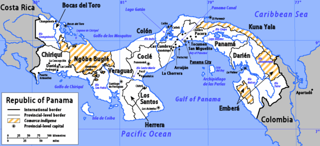
Summary
I am the author of this image file. Its contents are based in part on a map in the CIA World Factbook [1995 edition].
Further information
Sources
- The basic geographical detail for this map was copied from the map of Panama included in the 1995 edition of the CIA's World Factbook. The source map can be found via the University of Texas Perry-Castañeda Library Map Collection's page for Panama.
- Boundaries for the provinces (and for the comarcas indígenas with the status of a province) were checked against a map included in " Panamá en Cifras, 1999-2003", published in Nov. 2004 by the Panamanian government's Dirección General de Estadística y Censo (Directorate-General of Statistics and Census). Details of provincial and comarcal capitals were also checked against the same publication.
- Population figures for towns and cities (see below) were obtained from Thomas Brinkhoff's City Population website.
Content
- The map shows the provinces and three comarcas with provincial status. The two comarcas that don't have provincial status ( Kuna de Madungandí and Kuna de Waragandí) are not shown.
- All provincial and comarcal capitals are shown with a circled dot, with the exception of Unión Chocó (the capital of Emberá), which I was unable to find on any map to which I had access. Note that the position of Quebrada Guabo is approximate.
- All towns and cities with a population greater than 10,000 are shown on the map, unless in very close proximity to a larger town or city. Towns and cities with a population greater than 50,000 are shown with their names in a larger size. Some of the provincial/comarcal capitals have a smaller population than 10,000, and have their names in italics. Outside of the Rep. of Panama, only towns with a population larger than 50,000 are shown.
- The national capital is indicated with its name underlined.
Errata
- The capital of Los Santos province is in fact Las Tablas, and not Los Asientos.
Feedback
Please post any feedback to my talk page for maps.
Licensing
| |
This file is licensed under the Creative Commons Attribution ShareAlike 2.5 License. In short: you are free to share and make derivative works of the file under the conditions that you appropriately attribute it, and that you distribute it only under a license identical to this one. Official license |
File history
Click on a date/time to view the file as it appeared at that time.
| Date/Time | Dimensions | User | Comment | |
|---|---|---|---|---|
| current | 11:32, 10 January 2006 | 1,409×642 (88 KB) | SabineCretella | (copied from en.wikipedia: http://en.wikipedia.org/wiki/Image:Countries-Panama-provinces-2005-10-18-en.png The original contents of the page on en.wikipedia: == Summary == I am the author of this image file. Its contents are based in part on a map in the) |
File links
The following pages on Schools Wikipedia link to this image (list may be incomplete):