Image:Sy-map.png
From Wikipedia, the free encyclopedia
No higher resolution available.
Sy-map.png (328 × 352 pixels, file size: 12 KB, MIME type: image/png)
| |
This is a file from the Wikimedia Commons. The description on its description page there is shown below. |
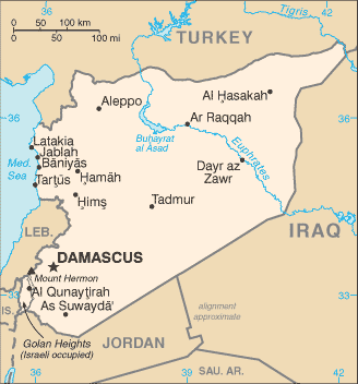
CIA map of syria
 |
This image is in the public domain because it contains materials that originally came from the United States Central Intelligence Agency's World Factbook. Deutsch | English | Español | Français | 日本語 | Nederlands | 한국어 | Português | தமிழ் | Magyar | +/- |
 |
 |
This map image should be recreated using vector graphics as an SVG file. This has several advantages; see Commons:Media for cleanup for more information. If an SVG form of this image is already available, please upload it. After uploading an SVG, replace this template with {{ vector version available|new image name.svg}}. |
|
العربية | Български | Català | Česky | Dansk | Deutsch | English | Esperanto | Español | Français | Galego | 한국어 | Italiano | Magyar | Lietuvių | Nederlands | 日本語 | Polski | Português | Română | Русский | Suomi | Svenska | Türkçe | Українська | 中文(繁體) | 中文(简体) | +/- |
|
File history
Click on a date/time to view the file as it appeared at that time.
| Date/Time | Dimensions | User | Comment | |
|---|---|---|---|---|
| current | 13:35, 12 May 2005 | 328×352 (12 KB) | Eirik | (CIA map of syria {{PD-USGov-CIA-WF}} Category:Maps of Syria ) |
File links
The following pages on Schools Wikipedia link to this image (list may be incomplete):
Categories: Maps of Syria