Image:LithuaniaPhysicalMap-Detailed.png
From Wikipedia, the free encyclopedia
Size of this preview: 640 × 453 pixels
Full resolution (2,366 × 1,675 pixels, file size: 2.41 MB, MIME type: image/png)
| |
This is a file from the Wikimedia Commons. The description on its description page there is shown below. |
Summary
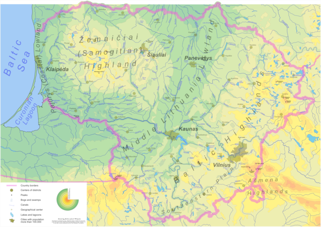
| Description |
Detailed Lithuania physical map with major cities, lakes, rivers, swamps highlighted English: Physical map of Lithuania. Click on the image for better resolution.
|
|---|---|
| Source |
digitized various sources |
| Date |
2005-2006 |
| Author |
Andrius Ramanauskas |
| Permission ( Reusing this image) |
GFDL |
| Other versions | vectoric source - Image:LithuaniaPhysicalMap-Detailed.svg |
Many thanks to Renata for support and multiple reviews, comments and suggstions
Licensing
|

File history
Click on a date/time to view the file as it appeared at that time.
| Date/Time | Dimensions | User | Comment | |
|---|---|---|---|---|
| current | 06:12, 5 June 2006 | 2,366×1,675 (2.41 MB) | Knutux | (updated version) |
| 14:24, 3 May 2006 | 2,366×1,675 (2.51 MB) | Knutux | (updating once more by comments) | |
| 13:25, 26 April 2006 | 2,366×1,675 (2.53 MB) | Knutux | (updated version (more river/city names, small corrections)) | |
| 05:40, 16 March 2006 | 3,548×2,512 (4.11 MB) | Knutux | (updated version (more details added - mostly river names)) | |
| 13:26, 10 March 2006 | 3,548×2,512 (3.86 MB) | Knutux | (new version) | |
| 07:34, 9 March 2006 | 4,731×3,349 (6.05 MB) | Knutux | (Detailed Lithuania physical map with major cities, lakes, rivers, swamps highlighted (work in progress)) |