Image:LithuaniaHistory.png
From Wikipedia, the free encyclopedia
Size of this preview: 418 × 480 pixels
Full resolution (1,519 × 1,743 pixels, file size: 574 KB, MIME type: image/png)
| |
This is a file from the Wikimedia Commons. The description on its description page there is shown below. |
Contents |
Summary
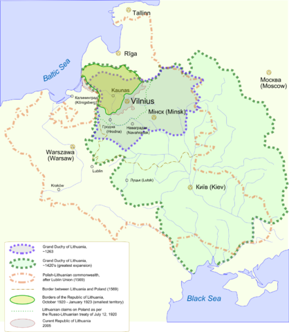
Lithuania history:
- 13th century (during the reign of Mindaugas)
- 15th century (during the reign of Vytautas the Great)
- Polish-Lithuanian Commonwealth and border between its parts
- Border of 1923 (the area of Vilnius being a part of Poland)
- Modern Republic of Lithuania
Légende
Histoire territoriale de la Lithuanie
- XIIIe siècle (règne de Mindaugas)
- XVe siècle (règne de Vytautas le Grand)
- Communauté Polono-lituanienne et frontière interne
- Frontière de 1923 (les environs de Vilnius sont polonais)
- République moderne de Lithuanie
Informacija
Lietuva įvairiais istoriniais laikotarpiais:
- Violetinė riba - Mindaugo laikų Lietuva
- Žalia - Vytauto laikų
- Oranžinė - LLV ( Abiejų Tautų Respublika). Punktyru - riba tarp Lietuvos ir Lenkijos
- Žalia - kaimyninių šalių (išskyrus Lenkiją) pripažinta 1923 metų siena
- Raudona - dabartinė Lietuvos Respublika
|
|
This file was a candidate on Picture of the Year 2006. This is a featured picture on Wikimedia Commons: it is considered one of our finest images. If you have an image of similar quality that can be published under a suitable copyright license, be sure to upload it, tag it, and nominate it. |
|
| |
This image was selected as a picture of the day for March 10, 2006. It was captioned as followed: English: Lithuania history map
Alemannisch: Chart vun de litauisch Gschicht
Česky: Historická mapa Litvy
Deutsch: Historische Karte von Litauen
English: Lithuania history map
Español: Mapa histórico de Lituania
Suomi: Kartta Liettuan historian eri vaiheista.
Français : Carte historique de la Lituanie.
Magyar: Litvánia történelmi térképe
Italiano: Mappa storica della Lituania dal XIII secolo ai nostri giorni
日本語: リトアニア歴史地図
Lëtzebuergesch: Historesch Kaart vu Litauen.
Norsk (nynorsk): Historisk kart over Litauen.
Polski: Historyczna mapa polityczna Litwy.
Português: Mapa histórico da Lituânia
Русский: Историческая карта Литвы
中文(简体): 立陶宛历史地图
|
Vector format
Image source (svg format) - Image:LithuanianHistory.svg
 A vector version of this image (SVG) is available. For more information about vector graphics, read about Commons transition to SVG. Deutsch | English | Español | Français | Galego | עברית | Magyar | Italiano | 日本語 | 한국어 | Lietuvių | Polski | Português | Русский | Српски / Srpski | Українська | +/- |
 |
Licensing
 |
I, the copyright holder of this work, hereby release it into the public domain. This applies worldwide. In case this is not legally possible: Afrikaans | Alemannisch | Aragonés | العربية | Asturianu | Български | Català | Cebuano | Česky | Cymraeg | Dansk | Deutsch | Eʋegbe | Ελληνικά | English | Español | Esperanto | Euskara | Estremeñu | فارسی | Français | Galego | 한국어 | हिन्दी | Hrvatski | Ido | Bahasa Indonesia | Íslenska | Italiano | עברית | Kurdî / كوردی | Latina | Lietuvių | Latviešu | Magyar | Македонски | Bahasa Melayu | Nederlands | Norsk (bokmål) | Norsk (nynorsk) | 日本語 | Polski | Português | Ripoarisch | Română | Русский | Shqip | Slovenčina | Slovenščina | Српски / Srpski | Suomi | Svenska | ไทย | Tagalog | Türkçe | Українська | Tiếng Việt | Walon | 中文(简体) | 中文(繁體) | zh-yue-hant | +/- |
File history
Click on a date/time to view the file as it appeared at that time.
| Date/Time | Dimensions | User | Comment | |
|---|---|---|---|---|
| current | 05:22, 21 December 2005 | 1,519×1,743 (574 KB) | Knutux | (Text changes (marked greatest expansion and smallest teritory in legend)) |
| 06:35, 19 December 2005 | 1,519×1,743 (559 KB) | Knutux | (a small correction) | |
| 06:33, 19 December 2005 | 1,519×1,743 (559 KB) | Knutux | (a better version) | |
| 07:54, 15 December 2005 | 1,518×1,741 (549 KB) | Knutux | (Updated current borders) | |
| 09:54, 14 December 2005 | 1,518×1,741 (547 KB) | Knutux | (added cities, labels in legend) | |
| 18:31, 12 December 2005 | 1,512×1,740 (428 KB) | Knutux | (Lithuania history: *13th age (Lithuania of the Mindaugas) *15th age (Vytautas the Great) *Polish-Lithuanian Comonwealth and border between those countries *Formal border of 1923 (Vilnius region was anexed by Poland) *Current Republic of Lithuania [[Categ) |