Image:Sweden in 1658.PNG

From Wikipedia, the free encyclopedia

Wikimedia Commons logo This is a file from the Wikimedia Commons. The description on its description page there is shown below.
Commons is a freely licensed media file repository. You can help.
Atlas This map has been uploaded by Electionworld from en.wikipedia.org to enable the Wikimedia Atlas of the World . Original uploader to en.wikipedia.org was Litany, known as Litany at en.wikipedia.org. Electionworld is not the creator of this map. Licensing information is below.
Description
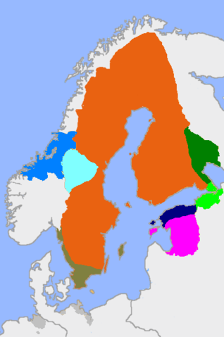
English: Sweden in 1658. The actual main part of the realm and the dominions in different colours

Key

  • Red: main part of the realm
  • Dark green: Kexholm County.
  • Light green: Ingermanland
  • Navy blue: Estonia
  • Magenta: Livonia
  • Dark grey: German dominions
  • Very dark green: Scania, Gotland, Bohuslän
  • Blue: Trondheim
  • Very light blue: Härjedalen
The borders toward Russia and Norway in Lapland are actually undefined, but drawn to approximate the area of Swedish influence.
Svenska: Sverige 1658.

Färgar

  • Röd: det egentliga riket
  • Mörkgrön: Kexholms län
  • Ljusgrön: Ingermanland
  • Mörkblå: Estland
  • Magenta: Livland
  • Mörkgrå: Svenska områden i Tyskland
  • Mycket mörk grön: Skåne, Gotland, Bohuslän
  • Blå: Trondheims län
  • Ljusblå: Härjedalen
Norra gränsen mot Norge och Ryssland är odefinierad.
Suomi: Ruotsin valtakunta vuonna 1658

Värit

  • Punainen: varsinainen valtakunta
  • Tummanvihreä: Käkisalmen lääni|Käkisalmen lääni
  • Vaaleanvihreä: Inkerinmaa
  • Tummansininen: Viro
  • Tummanharmaa: Ruotsin omistukset Saksan valtakunnassa
  • Myrkynvihreä: Skoone, Gotlanti, Bohuslän
  • Sininen: Trondheimin lääni
  • Vaaleanvihreä: Härjedalen
Valtakunnan pohjoisraja Lapissa on määrittelemätön.
Source

On the basis of former file version, using Image:Sweden_1658.jpg and Image:Historical provinces of sweden no national borders.png for help. This version differentiates between the actual main realm and does not have interference from contemporary borders.

Date

9-26-2007

Author

User:MPorciusCato, Litany

Permission
( Reusing this image)
I, the copyright holder of this work, have published or hereby publish it under the following license:
GNU head Permission is granted to copy, distribute and/or modify this document under the terms of the GNU Free Documentation license, Version 1.2 or any later version published by the Free Software Foundation; with no Invariant Sections, no Front-Cover Texts, and no Back-Cover Texts. A copy of the license is included in the section entitled " GNU Free Documentation license".

Aragonés | العربية | Asturianu | Беларуская (тарашкевіца) | Български | বাংলা | ইমার ঠার/বিষ্ণুপ্রিয়া মণিপুরী | Brezhoneg | Bosanski | Català | Cebuano | Česky | Dansk | Deutsch | Ελληνικά | English | Esperanto | Español | Eesti | Euskara | فارسی | Suomi | Français | Gaeilge | Galego | עברית | Hrvatski | Magyar | Bahasa Indonesia | Ido | Íslenska | Italiano | 日本語 | ქართული | ភាសាខ្មែរ | 한국어 | Kurdî / كوردی | Latina | Lëtzebuergesch | Lietuvių | Bahasa Melayu | Nnapulitano | Nederlands | ‪Norsk (nynorsk)‬ | ‪Norsk (bokmål)‬ | Occitan | Polski | Português | Română | Русский | Slovenčina | Slovenščina | Shqip | Српски / Srpski | Svenska | తెలుగు | ไทย | Tagalog | Türkçe | Українська | اردو | Tiếng Việt | Volapük | Yorùbá | ‪中文(简体)‬ | ‪中文(繁體)‬ | +/-


This map image should be recreated using vector graphics as an SVG file. This has several advantages; see Commons:Media for cleanup for more information. If an SVG form of this image is already available, please upload it. After uploading an SVG, replace this template with {{ vector version available|new image name.svg}}.

العربية | Български | Català | Česky | Dansk | Deutsch | English | Esperanto | Español | Français | Galego | 한국어 | Italiano | Magyar | Lietuvių | Nederlands | 日本語 | Polski | Português | Română | Русский | Suomi | Svenska | Türkçe | Українська | ‪中文(繁體)‬ | ‪中文(简体)‬ | +/-

File history

Click on a date/time to view the file as it appeared at that time.

Date/Time Dimensions User Comment
current 17:15, 26 September 2007 398×599 (63 KB) MPorciusCato ({{Information |Description={{en|Sweden in 1658. The actual main part of the realm and the dominions in different colours <br> '''Key''' *Red: main part of the realm *Dark green: Kexholm County. *Light green: [[:en:Ingermanland|Inge)
19:56, 21 February 2007 398×599 (66 KB) Tene (Optimised (0;4192))
15:53, 29 December 2006 398×599 (78 KB) Electionworld ({{ew|en|Litany}} == Summary == slightly modified map from http://en.wikipedia.org/wiki/Image:Sweden_1658.png, with extended german territories == Licensing == {{GFDL-self}} )
The following pages on Schools Wikipedia link to this image (list may be incomplete):
This Wikipedia DVD Selection has a sponsor: SOS Children , and is mainly selected from the English Wikipedia with only minor checks and changes (see www.wikipedia.org for details of authors and sources). See also our Disclaimer.