Image:Physical map of Romania.jpg

From Wikipedia, the free encyclopedia

Wikimedia Commons logo This is a file from the Wikimedia Commons. The description on its description page there is shown below.
Commons is a freely licensed media file repository. You can help.

Summary

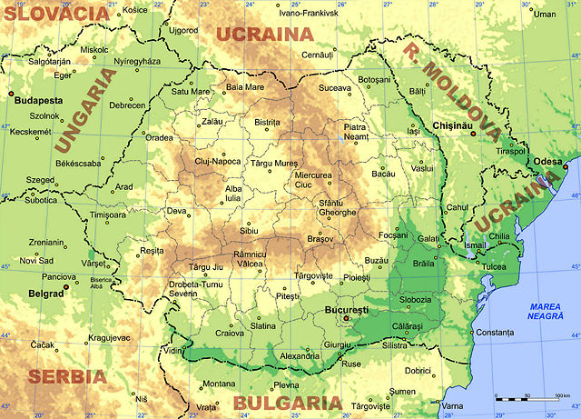
Physical map of Romania and surrounding areas, in bitmap format. Orthographic map projection with centre at 25 E, 46 N.

I created this map.

Keywords: Romania, map, physical map


Harta fizică a României în format bitmap. Proiecţie ortografică cu centrul la 25 E, 46 N.

Cuvinte cheie: România, hartă, harta fizică

Licensing

I, the copyright holder of this work, hereby publish it under the following licenses:
GNU head Permission is granted to copy, distribute and/or modify this document under the terms of the GNU Free Documentation license, Version 1.2 or any later version published by the Free Software Foundation; with no Invariant Sections, no Front-Cover Texts, and no Back-Cover Texts. A copy of the license is included in the section entitled " GNU Free Documentation license".

Aragonés | العربية | Asturianu | Беларуская (тарашкевіца) | Български | বাংলা | ইমার ঠার/বিষ্ণুপ্রিয়া মণিপুরী | Brezhoneg | Bosanski | Català | Cebuano | Česky | Dansk | Deutsch | Ελληνικά | English | Esperanto | Español | Eesti | Euskara | فارسی | Suomi | Français | Gaeilge | Galego | עברית | Hrvatski | Magyar | Bahasa Indonesia | Ido | Íslenska | Italiano | 日本語 | ქართული | ភាសាខ្មែរ | 한국어 | Kurdî / كوردی | Latina | Lëtzebuergesch | Lietuvių | Bahasa Melayu | Nnapulitano | Nederlands | ‪Norsk (nynorsk)‬ | ‪Norsk (bokmål)‬ | Occitan | Polski | Português | Română | Русский | Slovenčina | Slovenščina | Shqip | Српски / Srpski | Svenska | తెలుగు | ไทย | Tagalog | Türkçe | Українська | اردو | Tiếng Việt | Volapük | Yorùbá | ‪中文(简体)‬ | ‪中文(繁體)‬ | +/-

Creative Commons License
Creative Commons Attribution icon
This file is licensed under Creative Commons Attribution 2.5 License
In short: you are free to distribute and modify the file as long as you attribute its author(s) or licensor(s).

You may select the license of your choice.

File history

Click on a date/time to view the file as it appeared at that time.

Date/Time Dimensions User Comment
current 03:31, 28 May 2006 1,024×738 (438 KB) AdiJapan (Same as before. Updated country name for Serbia.)
09:44, 8 March 2006 1,024×738 (372 KB) AdiJapan (Same as previous version.)
17:02, 16 February 2006 1,024×738 (363 KB) AdiJapan (Physical map of Romania and surrounding areas, in bitmap format. Plane projection with centre at 25 E, 46 N. I created this map. Keywords: Romania, map, physical map ---- Harta fizică a României în format bitmap. Proiecţie plană cu centrul la 25 E,)
The following pages on Schools Wikipedia link to this image (list may be incomplete):
This Wikipedia Selection is sponsored by SOS Children , and is a hand-chosen selection of article versions from the English Wikipedia edited only by deletion (see www.wikipedia.org for details of authors and sources). See also our Disclaimer.