Image:Agasthiyamalai range and Tirunelveli rainshadow.jpg
From Wikipedia, the free encyclopedia
Size of this preview: 640 × 480 pixels
Full resolution (1,280 × 960 pixels, file size: 241 KB, MIME type: image/jpeg)
| |
This is a file from the Wikimedia Commons. The description on its description page there is shown below. |
|
|
This file was a candidate on Picture of the Year 2006. This was formerly a featured picture.
|
|
| Description |
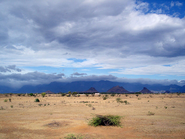
English: The Agasthiyamalai range of the western ghats as seen from the rainshadow region of Tirunelveli, India. The southwest monsoon brings rain up to the ghats in Kerala while the other side in Tamil Nadu remains dry.
Français : La chaine du mont Agasthiyamalai, au sud des Ghâts occidentaux, vue depuis la région de Tirunelveli, dans le Tamil Nadu, en Inde. Cette région constitute un désert d'abri: les masses d'air humide de la mousson s'élèvent le long des Ghâts occidentaux, et produisent des pluies qui s'abattent sur l'état du Kérala, à l'ouest. A l'est de la montagne, la plaine reste sèche.
|
|||||
|---|---|---|---|---|---|---|
| Source |
Photo by w:user:PlaneMad |
|||||
| Date |
13 August 2006 |
|||||
| Author |
w:user:PlaneMad |
|||||
| Permission ( Reusing this image) |
|

| Camera location |
|
See this image at its location on Google Maps This location on: Live Maps - Trails.com - TerraServer-USA |
|---|
| This was formerly a featured picture. |
| |
This image was selected as a picture of the day for June 02, 2007. It was captioned as followed: English: The Agasthiyamalai range of the western ghats as seen from the rainshadow region of Tirunelveli, India.
Беларуская: Горны ланцуг Агастамалаі, частка Заходніх Гат, від з раёна Цірунелвелі штата Таміл Наду (Індыя)
Česky: Pouštní oblast v jižní Indii, vzniklá srážkovým stínem vysočiny Agasthiyamalai
English: The Agasthiyamalai range of the western ghats as seen from the rainshadow region of Tirunelveli, India.
Español: La cadena montañosa Agasthyamalai, perteneciente a las Ghats Occidentales, vista desde la región de Tirunelveli, India.
Français : La chaîne de montagnes Agasthyamalai des ghâts occidentaux, vue depuis la région de Tirunelveli, Inde.
Magyar: Az Agasthyamalai hegy az indiai Nyugati-Ghat hegységben, Tirunelveli felől nézve.
Italiano: La catena dell'Agasthiyamalai dei Ghats Occidentali come vista dalla regione arida del Tirunelveli, India.
日本語: インド南部、 ティルネルヴェーリの 雨蔭地帯から見た 西ガーツ山脈のアガスティヤマライ山地
Nederlands: De Agastya Malai-bergrug van de West-Ghats gezien vanaf de regenschaduwzijde bij Tirunelveli in India.
Polski: Łańcuch górski Agasthiyamalai w Ghattach Zachodnich widok z dystryku Tirunelveli, w stanie Tamil Nadu w Indiach.
Português: Pico Agastya Malai na Índia. A monção do sudoeste traz chuva sobre a cadeia de montanhas do Kerala, enquanto o outro lado em Tamil Nadu, permanece seco.
Русский: Горная цепь Agasthyamalai Западных Гат, вид из округа Тирунелвели, Индия.
Svenska: Bergryggen Agastya Malai i Västra Ghats sedd från regnskuggeområdet runt Tirunelveli i Tamil Nadu i södra Indien.
中文(简体): 东坡被雨水覆盖而西坡干燥的 印度 西高止山南端。
中文(繁體): 從 印度蒂魯內爾維利的雨影地帶眺望 西高止山的阿伽斯提亞·馬來山脈
|
File history
Click on a date/time to view the file as it appeared at that time.
| Date/Time | Dimensions | User | Comment | |
|---|---|---|---|---|
| current | 13:14, 21 August 2006 | 1,280×960 (241 KB) | PlaneMad | (== Summary == {{Information| |Description= The w:Agasthiyamalai range of the western ghats as seen from the w:rainshadow region of w:Tirunelveli, India. The southwest monsoon brings rain upto the ghats in w:Kerala while the other side in [) |
File links
Metadata
This file contains additional information, probably added from the digital camera or scanner used to create or digitize it. If the file has been modified from its original state, some details may not fully reflect the modified file.
| Camera manufacturer | SONY |
|---|---|
| Camera model | DSC-W5 |
| Exposure time | 1/800 sec (0.00125) |
| F-number | f/5.6 |
| Date and time of data generation | 08:14, 13 August 2006 |
| Lens focal length | 7.9 mm |
| Orientation | Normal |
| Horizontal resolution | 72 dpi |
| Vertical resolution | 72 dpi |
| Software used | Adobe Photoshop CS2 Windows |
| File change date and time | 13:25, 21 August 2006 |
| Y and C positioning | 2 |
| Exposure Program | Landscape mode (for landscape photos with the background in focus) |
| ISO speed rating | 100 |
| Exif version | 2.2 |
| Date and time of digitizing | 08:14, 13 August 2006 |
| Image compression mode | 4 |
| Exposure bias | 0 |
| Maximum land aperture | 3 |
| Metering mode | CenterWeightedAverage |
| Light source | Unknown |
| Flash | 16 |
| Colour space | sRGB |
| Custom image processing | Normal process |
| Exposure mode | Auto exposure |
| White balance | Auto white balance |
| Scene capture type | Landscape |
| Contrast | Normal |
| Saturation | Normal |
| Sharpness | Normal |