Image:Sahara dust plume Nov 1998.jpg
From Wikipedia, the free encyclopedia
Size of this preview: 640 × 454 pixels
Full resolution (4,449 × 3,156 pixels, file size: 5.06 MB, MIME type: image/jpeg)
| |
This is a file from the Wikimedia Commons. The description on its description page there is shown below. |
| Description |
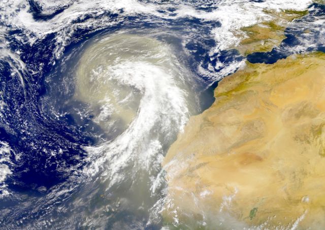
Dust plume off the Sahara desert over the northeast Atlantic Ocean. The Azores are visible at the northwest edge of the dust plume in this SeaWiFS image. The Cape Verde Islands can be seen through the dust near the bottom of the image. Sensor: OrbView-2/SeaWiFS |
|---|---|
| Source |
NASA Visible Earth |
| Date |
01 November 1998 |
| Author |
Provided by the SeaWiFS Project, NASA/Goddard Space Flight Centre, and ORBIMAGE |
| Permission ( Reusing this image) |
see below
|
Licensing
 |
This image is from the Sea-viewing Wide Field-of-view Sensor (SeaWiFS) Project. Satellite data captured by the SeaWIFS sensor are released into the public domain 5 years after capture. Data less than five years old can be re-used only for educational or scientific purposes; any commercial use of such images must be coordinated with ORBIMAGE/GeoEye. |
File history
Click on a date/time to view the file as it appeared at that time.
| Date/Time | Dimensions | User | Comment | |
|---|---|---|---|---|
| current | 00:01, 6 November 2005 | 4,449×3,156 (5.06 MB) | Tintazul | ({{Information| |Description=Dust plume off the Sahara desert over the northeast Atlantic Ocean. The Azores are visible at the northwest edge of the dust plume in this SeaWiFS image. The Cape Verde Islands can be seen through the dust near the bottom of th) |
File links
The following pages on Schools Wikipedia link to this image (list may be incomplete):