Image:Map Canada political-geo.png
From Wikipedia, the free encyclopedia
Size of this preview: 544 × 479 pixels
Full resolution (1,280 × 1,128 pixels, file size: 496 KB, MIME type: image/png)
| |
This is a file from the Wikimedia Commons. The description on its description page there is shown below. |
 |
This map image should be recreated using vector graphics as an SVG file. This has several advantages; see Commons:Media for cleanup for more information. If an SVG form of this image is already available, please upload it. After uploading an SVG, replace this template with {{ vector version available|new image name.svg}}. |
|
العربية | Български | Català | Česky | Dansk | Deutsch | English | Esperanto | Español | Français | Galego | 한국어 | Italiano | Magyar | Lietuvių | Nederlands | 日本語 | Polski | Português | Română | Русский | Suomi | Svenska | Türkçe | Українська | 中文(繁體) | 中文(简体) | +/- |
|
| Description |
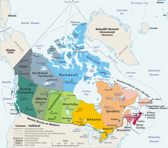
Map: Canada – geopolitical Drawn and adapted by E Pluribus Anthony from Atlas of Canada Edited by en:User:Heqs/ en:User:Cogito ergo sumo to show disputed nature of Canada's marine international boundary claims; see en:Canada-United_States_border#Remaining_boundary_disputes |
|---|---|
| Source |
Originally from en.wikipedia; description page is/was here. |
| Date |
2006-03-11 (first version); 2006-09-09 (last version) |
| Author |
Original uploader was E Pluribus Anthony at en.wikipedia Later versions were uploaded by AThing, Heqs, Cogito ergo sumo at en.wikipedia. |
| Permission ( Reusing this image) |
Released into the public domain (by the author).
|
License information
 |
This image has been (or is hereby) released into the public domain by its author, E Pluribus Anthony at the wikipedia project. This applies worldwide. In case this is not legally possible: |
Original upload log
(All user names refer to en.wikipedia)
- 2006-09-09 19:01 Cogito ergo sumo 1280×1128×8 (508303 bytes) Map: Canada – geopolitical, including disputed international boundaries; corrected Yukon & QC lake names
- 2006-09-09 18:25 Cogito ergo sumo 1280×1128×8 (509935 bytes) Map: Canada – geopolitical, including disputed international boundaries; corrected QC lake names
- 2006-09-03 21:01 Cogito ergo sumo 1280×1128×8 (508812 bytes) Map: Canada – geopolitical, including disputed international boundaries
- 2006-09-03 17:42 Cogito ergo sumo 1280×1128×8 (509203 bytes) Map: Canada – geopolitical, including disputed international boundaries
- 2006-07-27 20:34 Heqs 1280×1128×8 (546411 bytes) fixing coloring error in NWT
- 2006-07-27 06:14 Heqs 1280×1128×8 (547065 bytes) forgot [[Dixon Entrance]]
- 2006-07-27 05:33 Heqs 1280×1128×8 (548660 bytes) Corrected to show the disputed nature of Canada's marine arctic international boundary claim.
- 2006-04-15 16:37 AThing 1280×1128×8 (477519 bytes) Ran it through OptiPNG.
- 2006-04-10 01:52 E Pluribus Anthony 1280×1128×8 (505317 bytes) Map: Canada – geopolitical
- 2006-03-11 11:09 E Pluribus Anthony 1280×1128×8 (506013 bytes) Map: Canada – geopolitical
File history
Click on a date/time to view the file as it appeared at that time.
| Date/Time | Dimensions | User | Comment | |
|---|---|---|---|---|
| current | 19:54, 15 June 2007 | 1,280×1,128 (496 KB) | PMG | ({{Information |Description=Map: en:Canada – geopolitical Drawn and adapted by E Pluribus Anthony from [http://atlas.gc.ca/site/english/maps/reference/national/can_political_e Atlas of Canada] Edited by [[:en:User:H) |
File links