Image:Canada provinces evolution.gif
From Wikipedia, the free encyclopedia
Size of this preview: 555 × 480 pixels
Full resolution (1,000 × 864 pixels, file size: 247 KB, MIME type: image/gif)
| |
This is a file from the Wikimedia Commons. The description on its description page there is shown below. |
| This is a featured picture, which means that members of the community have identified it as one of the finest images on the English Wikipedia, adding significantly to its accompanying article. If you have a different image of similar quality, be sure to upload it using the proper free license tag, add it to a relevant article, and nominate it. |
|
|
This file was a candidate on Picture of the Year 2007. This is a featured picture on Wikimedia Commons: it is considered one of our finest images. This is a featured picture on English Wikipedia and is considered one of the finest images. If you have an image of similar quality that can be published under a suitable copyright license, be sure to upload it, tag it, and nominate it. |
|
| |
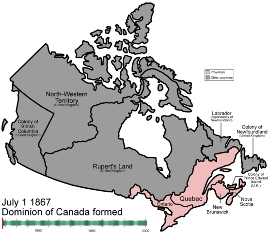
This image was selected as a picture of the day for March 08, 2008. It was captioned as followed: English: An animated GIF of the evolution of Canada's internal borders, from the formation of the dominion to the present.
Afrikaans: Engelstalige animasie wat die ontwikkeling van die interne grense van Kanada uitbeeld vanaf 1867 tot op hede.
Asturianu: Una animación col desendolcu de les llendes internes de Canadá, dende la so nacencia hasta anguaño.
Беларуская: Эвалюцыя адміністрацыйных межаў Канады, ад 1867 да сучаснасці.
Česky: Animace historického geografického dělení státu Kanada
Dansk: Animation af Canadas territoriale udvikling fra grundlæggelsen som Dominion til i dag.
Deutsch: Animation der territorialen Entwicklung Kanadas von der Gründung des Dominion bis heute.
English: An animated GIF of the evolution of Canada's internal borders, from the formation of the dominion to the present.
Español: Una animación con la evolución de las fronteras internas de Canadá, desde su nacimiento hasta la actualidad.
Euskara: Kanadako barne-mugen bilakaera, sorreratik gaur egun arte.
Français : GIF animé de l'évolution des frontières internes du Canada, depuis la formation du dominion jusqu'à présent.
Galego: Evolución das fronteiras interiores de Canadá, desde o nacemento ata a actualidade.
Magyar: Animáció Kanada belső határainak változásáról az államszövetség megalakulásától napjainkig
Íslenska: Hreyfimynd sem sýnir þróun landamæra Kanada til dagsins í dag.
Italiano: Animazione dell'evoluzione dei confini interni del Canada.
日本語: GIFアニメーションによる カナダ国内の境界の進展。 自治領の形態から現在まで。
한국어: 캐나다 주(州) 경계의 변천을 표현한 애니메이션. 자치령 형성 때부터 현재까지.
Norsk (bokmål): Animasjon av Canadas territoriale utvikling fra dannelsen av dominionen til i dag.
Nederlands: Engelstalige animatie van de ontwikkeling van de interne grenzen van Canada van de Dominion of Canada in 1867 tot heden
Norsk (nynorsk): Animasjon av Canadas territoriale utvikling frå danninga av dominionen fram til i dag.
Polski: Animowana mapa ewolucji podziału administracyjnego Kanady.
Português: Uma animação com a evolução das fronteiras do Canadá, desde o seu nascimento até os dias atuais.
Română: Un GIF animat care arată modificarea graniţelor Canadei, de la formarea dominionului până în prezent.
Slovenčina: Animácia historického geografického členenia štátu Kanada
Српски / Srpski: Анимација историје промена унутрашњих (административних) граница Канаде, од Доминиона до данас.
Svenska: Animering över gräns- och namnändringar för Kanadas provinser och territorier sedan 1867.
中文(简体): 从独立至今 加拿大省的变迁
中文(繁體): 一幅顯示了 加拿大國內邊界變化的動畫,從 自治領的成立至現在
|
Summary
| Description |
English: An animated GIF of the evolution of Canada's internal borders, from the formation of the dominion to the present.
Español: GIF animado de la evolución de las fronteras internas de Canadá, desde la formación del dominio hasta ahora.
Français : GIF animé de l'évolution des frontières internes du Canada, depuis la formation du dominion jusqu'à présent.
日本語: アニメーションGIFによるカナダ州境の変遷、自治領の形成から現在まで。
한국어: 한국어: 캐나다 주(州) 경계의 변천을 표현한 애니메이션. 자치령 형성 때부터 현재까지.
Português: GIF animado da evolução das fronteiras internas do Canadá, desde a formação do domínio até ao presente.
中文: 从独立至今 加拿大省的变迁。
|
|---|---|
| Source |
self-made |
| Date | |
| Author |
Made by User:Golbez. |
| Permission ( Reusing this image) |
see below
|
Licensing
|

See also
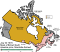 single frame useful for thumbnail purposes |
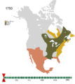 All of North America |
 |
This image has been assessed using the Quality image guidelines and is considered a Quality image. |
File history
Click on a date/time to view the file as it appeared at that time.
| Date/Time | Dimensions | User | Comment | |
|---|---|---|---|---|
| current | 12:45, 28 February 2007 | 1,000×864 (247 KB) | Golbez | (Fixed minor text problem) |