Image:VaticanCity Annex.jpg
From Wikipedia, the free encyclopedia
Size of this preview: 598 × 479 pixels
Full resolution (2,625 × 2,104 pixels, file size: 261 KB, MIME type: image/jpeg)
| |
This is a file from the Wikimedia Commons. The description on its description page there is shown below. |
 |
This map has been uploaded by Electionworld from en.wikipedia.org to enable the |
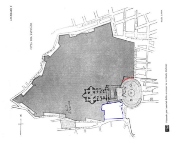
- Description: Boundary map taken from the annex of the lateran treaties. Colored areas are modifications of original image for purposes of clarification.
- Source: German Wikipedia
Details
- dark grey: territory of Vatican City.
- light grey: territory of Vatican City. Security dispositive of Italy. Free access to public and to Italian police authorities may be revoked at any time for special ceremonial occasions.
- red: The small strip (3 m wide, 60 m long) alongside the northern colonnade is - according to the Lateran treaties - Italian territory and underlies Italian jurisdiction. This fact has been disputed by the mixed Italian-Vatican commission which was in place until 1932 to refine and detail the findings of the treaties. Since this commission had only a consultatory status Italy does not recognize any legal relevance of this dispute.
- blue zone: territory of Italy, but in possession of the Holy See. The area has extraterritorial status and Italian jurisdiction is not applied. The area contains the seat of the Congregation for the Doctrine of the Faith, the bigger part of the audience hall Paul VI. the Campo Santo Teutonico and the German College.
- other: The light grey area next to the station was evidently been added in by mistake and is Italian territory.
Licensing
 |
This image (or other media file) is in the public domain because its copyright has expired. This applies to the United States, Canada, the European Union and those countries with a copyright term of life of the author plus 70 years. العربية | Asturianu | Български | Català | Česky | Dansk | Deutsch | English | Ελληνικά | Esperanto | Español | Euskara | فارسی | Français | Gaeilge | Galego | עברית | हिन्दी | Bahasa Indonesia | Italiano | 日本語 | 한국어 | Kurdî / كوردی | Lietuvių | Magyar | Nederlands | Norsk (nynorsk) | Македонски | Bahasa Melayu | Polski | Português | Română | Русский | Slovenčina | Slovenščina | Shqip | Suomi | Sámegiella | Türkçe | 中文(简体) | 中文(繁體) | 粵語 | +/- |
File history
Click on a date/time to view the file as it appeared at that time.
| Date/Time | Dimensions | User | Comment | |
|---|---|---|---|---|
| current | 22:37, 20 December 2006 | 2,625×2,104 (261 KB) | Electionworld | ({{ew|en|El Suizo}} *Description: Boundary map taken from the annex of the lateran treaties. Colored areas are modifications of original image for purposes of clarification. *Source: German Wikipedia ==Details== * '''dark grey''': territory of Vatican Cit) |