Image:Qa-map.PNG
From Wikipedia, the free encyclopedia
Size of this preview: 219 × 479 pixels
Full resolution (326 × 713 pixels, file size: 19 KB, MIME type: image/png)
| |
This is a file from the Wikimedia Commons. The description on its description page there is shown below. |
La bildo estas kopiita de wikipedia:en. La originala priskribo estas:
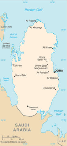
Map of Qatar.
Русский: Катар карта
 |
This image is in the public domain because it contains materials that originally came from the United States Central Intelligence Agency's World Factbook. Deutsch | English | Español | Français | 日本語 | Nederlands | 한국어 | Português | தமிழ் | Magyar | +/- |
 |
| date/time | username | edit summary |
|---|---|---|
| 07:25, 11 December 2004 | en:User:Neutrality | ({{PD-USGov-CIA-WF}}) |
| 01:04, 30 September 2004 | en:User:Quadell | ({{PD-USGov}}) |
| 18:48, 29 April 2004 | en:User:Quadell | (From the CIA Factbook. {{msg:PD}}) |
Historio de la dosiero
Legend: (cur) = this is the current file, (del) = delete this old version, (rev) = revert to this old version.
Click on date to download the file or see the image uploaded on that date.
- (del) (cur) 18:48, 29 April 2004 . . en:User:Quadell Quadell ( en:User_talk:Quadell Talk) . . 326x713 (19852 bytes) (From the CIA Factbook. { { msg:PD } })
File history
Click on a date/time to view the file as it appeared at that time.
| Date/Time | Dimensions | User | Comment | |
|---|---|---|---|---|
| current | 19:36, 29 January 2006 | 326×713 (19 KB) | Maksim | (La bildo estas kopiita de wikipedia:en. La originala priskribo estas: Map of Qatar. {{PD-USGov-CIA-WF}} {| border="1" ! date/time || username || edit summary |---- | 07:25, 11 December 2004 || en:User:Neutrality || <nowiki>({{PD-USGov-CIA-WF}})) |
File links
The following pages on Schools Wikipedia link to this image (list may be incomplete):