Image:Karte berliner mauer en.jpg
From Wikipedia, the free encyclopedia
Size of this preview: 596 × 479 pixels
Full resolution (1,368 × 1,100 pixels, file size: 244 KB, MIME type: image/jpeg)
| |
This is a file from the Wikimedia Commons. The description on its description page there is shown below. |
| |
This image was uploaded in the JPEG format even though it consists of non-photographic data. The information it contains could be stored more efficiently or more accurately in the PNG format or SVG format. If possible, please upload a PNG or SVG version of this image, derived from a non-JPEG source so that it doesn't contain any compression artifacts (or with existing artifacts removed) and with transparency where appropriate. After doing so, please replace all instances of the JPEG version throughout Wikipedia (noted under the "File links" header), tag the JPEG version with {{ obsolete|NewImage.ext}}, and remove this tag. For more information, see Wikipedia:Preparing images for upload. |
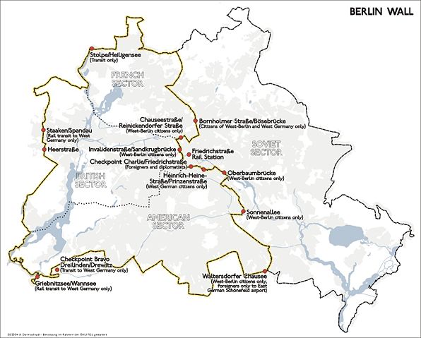
Map Shows the Berlin Wall and the border control checkpoints until 1989.
Composed in 2004 by de:Benutzer:Sansculotte. Usage granted under the conditions of the GNU FDL and the CCBYSA 2.0.
Quellenangabe und Beleg an sansculotte@despammed.com erbeten.
| |
This file is licensed under Creative Commons Attribution ShareAlike 2.0 Germany License Diese Datei ist lizenziert unter der Creative-Commons-Lizenz Namensnennung-Weitergabe unter gleichen Bedingungen 2.0 Deutschland |
|
 |
Permission is granted to copy, distribute and/or modify this document under the terms of the GNU Free Documentation license, Version 1.2 or any later version published by the Free Software Foundation; with no Invariant Sections, no Front-Cover Texts, and no Back-Cover Texts. A copy of the license is included in the section entitled " GNU Free Documentation license". Aragonés | العربية | Asturianu | Беларуская (тарашкевіца) | Български | বাংলা | ইমার ঠার/বিষ্ণুপ্রিয়া মণিপুরী | Brezhoneg | Bosanski | Català | Cebuano | Česky | Dansk | Deutsch | Ελληνικά | English | Esperanto | Español | Eesti | Euskara | فارسی | Suomi | Français | Gaeilge | Galego | עברית | Hrvatski | Magyar | Bahasa Indonesia | Ido | Íslenska | Italiano | 日本語 | ქართული | ភាសាខ្មែរ | 한국어 | Kurdî / كوردی | Latina | Lëtzebuergesch | Lietuvių | Bahasa Melayu | Nnapulitano | Nederlands | Norsk (nynorsk) | Norsk (bokmål) | Occitan | Polski | Português | Română | Русский | Slovenčina | Slovenščina | Shqip | Српски / Srpski | Svenska | తెలుగు | ไทย | Tagalog | Türkçe | Українська | اردو | Tiếng Việt | Volapük | Yorùbá | 中文(简体) | 中文(繁體) | +/- |
File history
Click on a date/time to view the file as it appeared at that time.
| Date/Time | Dimensions | User | Comment | |
|---|---|---|---|---|
| current | 17:51, 30 July 2005 | 1,368×1,100 (244 KB) | Sansculotte | (Map Shows the Berlin Wall and the border control checkpoints until 1989. Composed in 2004 by de:Benutzer:Sansculotte. Usage granted under the conditions of the GNU FDL and the CCBYSA 2.0. '''Quellenangabe und Beleg an [mailto:sansculotte@despam) |