Image:Iceland satellite.jpg
From Wikipedia, the free encyclopedia
Size of this preview: 624 × 480 pixels
Full resolution (2,600 × 2,000 pixels, file size: 869 KB, MIME type: image/jpeg)
| |
This is a file from the Wikimedia Commons. The description on its description page there is shown below. |
| Description |
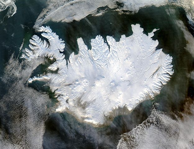
English: Iceland, from the NASA Visible Earth image gallery. More info below
|
|||||
|---|---|---|---|---|---|---|
| Source |
http://veimages.gsfc.nasa.gov/6605/Iceland.A2004028.1355.250m.jpg |
|||||
| Date |
29/JAN/2004 |
|||||
| Author |
Jeff Schmaltz |
|||||
| Permission ( Reusing this image) |
|


Picture info
- Description and alternative versions http://visibleearth.nasa.gov/view_rec.php?id=6605
- Metadata: Sensor Aqua/MODIS
- Visualization Date: 2004-01-29
- Credit: Jeff Schmaltz, MODIS Rapid Response Team, NASA/GSFC
- Description: Iceland lives up to its name in this image, acquired by the Moderate Resolution Imaging Spectroradiometer (MODIS) on NASA's Terra satellite on January 28, 2004. The island country is completely covered in white snow and ice, obscuring the permanent glaciers and icecaps that exist year-round. The effect of ice on this island sandwiched between the North Atlantic and the Greenland Sea, just below the Arctic Circle, is visible along its rugged northern shores. Over millennia, ice has carved out deep fjords leaving fringes of land that extend like fingers into the ocean.
- Source: ”The purpose of NASA's Earth Observatory is to provide a freely-accessible publication on the Internet where the public can obtain new satellite imagery and scientific information about our home planet. The focus is on Earth's climate and environmental change. In particular, we hope our site is useful to public media and educators. Any and all materials published on the Earth Observatory are freely available for re-publication or re-use, except where copyright is indicated. We ask that NASA's Earth Observatory be given credit for its original materials.”
File history
Click on a date/time to view the file as it appeared at that time.
| Date/Time | Dimensions | User | Comment | |
|---|---|---|---|---|
| current | 05:49, 5 December 2004 | 2,600×2,000 (869 KB) | Ævar Arnfjörð Bjarmason | (bigger version) |
| 12:06, 6 November 2004 | 540×405 (68 KB) | Ranveig | (NASA satelite image of Iceland) |
File links
The following pages on Schools Wikipedia link to this image (list may be incomplete):