Image:DRGMap.png
From Wikipedia, the free encyclopedia
Size of this preview: 384 × 479 pixels
Full resolution (900 × 1,123 pixels, file size: 725 KB, MIME type: image/png)
| |
This is a file from the Wikimedia Commons. The description on its description page there is shown below. |
 |
This map image should be recreated using vector graphics as an SVG file. This has several advantages; see Commons:Media for cleanup for more information. If an SVG form of this image is already available, please upload it. After uploading an SVG, replace this template with {{ vector version available|new image name.svg}}. |
|
العربية | Български | Català | Česky | Dansk | Deutsch | English | Esperanto | Español | Français | Galego | 한국어 | Italiano | Magyar | Lietuvių | Nederlands | 日本語 | Polski | Português | Română | Русский | Suomi | Svenska | Türkçe | Українська | 中文(繁體) | 中文(简体) | +/- |
|
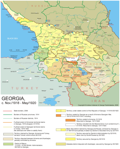
The Democratic Republic of Georgia from March 1919 to March 1920. Consult the legend for further information.
Copyright © 2006 Andrew Andersen. Uploaded by w:en:user:Aivazovsky.
Atlas of Conflicts
 |
The copyright holder of this file allows anyone to use it for any purpose, provided that credit is given and copyright is attributed.. |
| |
Please check that the conditions given above are compliant to the Commons licensing policy. Most importantly, derivative work and commercial use must be allowed. Česky | Dansk | Deutsch | English | Español | Français | Italiano | 日本語 | 한국어 | Kurdî / كوردی | Nederlands | Polski | Português | Русский | +/- |
File history
Click on a date/time to view the file as it appeared at that time.
| Date/Time | Dimensions | User | Comment | |
|---|---|---|---|---|
| current | 16:35, 20 January 2007 | 900×1,123 (725 KB) | Aivazovsky |
File links
The following pages on Schools Wikipedia link to this image (list may be incomplete):