Image:Pakistan earthquake satellite.jpg
From Wikipedia, the free encyclopedia
Size of this preview: 480 × 480 pixels
Full resolution (540 × 540 pixels, file size: 118 KB, MIME type: image/jpeg)
| |
This is a file from the Wikimedia Commons. The description on its description page there is shown below. |
Licensing
 |
This file is in the public domain because it was created by NASA. NASA copyright policy states that "NASA material is not protected by copyright unless noted". ( NASA copyright policy page or JPL Image Use Policy)
|
| Description |
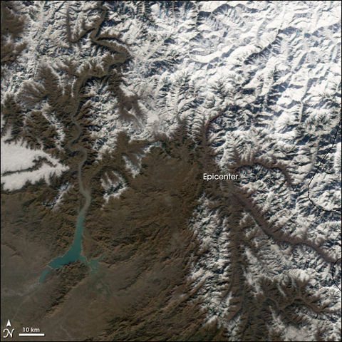
On October 8, 2005, a large earthquake shook the mountainous Kashmir region near the border of Pakistan and India. Tens of thousands of people died, and many more were isolated in the mountains by damage to roads and bridges as well as by landslides. Heavy winter snowfall poses an additional threat to millions of survivors made homeless by the quake. In the first week of January 2006, a new snow storm blanketed the mountains of Pakistan, including the region around the epicenter of the quake. This image from the Moderate Resolution Imaging Spectroradiometer (MODIS) on NASA’s Aqua satellite shows snow highlighting the ridges and ravines in the mountains northeast of the city of Islamabad on January 6. According to news reports on the BBC Website, the snow is hampering aid efforts to some areas, and avalanches triggered by earthquake aftershocks continue to threaten people in some mountainous areas. |
|---|---|
| Source |
http://earthobservatory.nasa.gov/Newsroom/NewImages/images.php3?img_id=17153 |
| Date |
2006-01-06 |
| Author |
Jesse Allen, Earth Observatory, using data obtained courtesy of the MODIS Rapid Response team. |
| Permission ( Reusing this image) |
see below
|
Licensing
 |
This file is in the public domain because it was created by NASA. NASA copyright policy states that "NASA material is not protected by copyright unless noted". ( NASA copyright policy page or JPL Image Use Policy). Deutsch | English | Español | Français | Galego | Nederlands | Português | Русский | 中文(简体) | 中文(繁體) | +/- |
|
 |
Warnings:
|
File history
Click on a date/time to view the file as it appeared at that time.
| Date/Time | Dimensions | User | Comment | |
|---|---|---|---|---|
| current | 18:41, 15 January 2006 | 540×540 (118 KB) | Bantman | (NASA satellite image (Aqua satellite, MODIS imager) of region surrounding epicenter of 2005 Kashmir earthquake, taken January 6, 2006.) |