Image:Honduras rel 1985.jpg
From Wikipedia, the free encyclopedia
Size of this preview: 580 × 480 pixels
Full resolution (1,249 × 1,033 pixels, file size: 246 KB, MIME type: image/jpeg)
| |
This is a file from the Wikimedia Commons. The description on its description page there is shown below. |
Summary
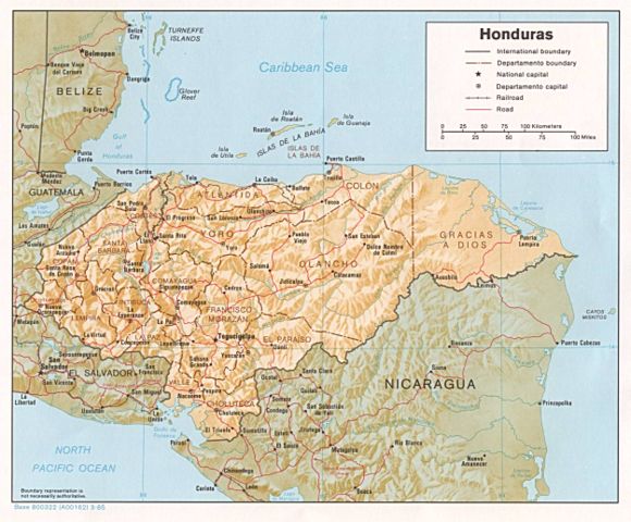
| Description |
Shaded relief map of Honduras, in year 1985, showing more than 45 Honduras towns, plus 40 bordering towns, in original JPEG format, 1249 x 1033 pixel, 246kb (labeled for large resizing > 600px width). |
|---|---|
| Source |
Image source URL: http://www.lib.utexas.edu/maps/americas/honduras.jpg; there was no copyright restriction on the containing webpage of the UT Library: UT Perry-Castañeda Library Map Collection - Honduras Maps. |
| Date |
Uploaded 28-October-2005 |
| Author |
US CIA (archived by UT Library) |
| Permission ( Reusing this image) |
(see below) |
| Other versions | (none yet) |
License
 |
This image is a work of a Central Intelligence Agency employee, taken or made during the course of the person's official duties. As a Work of the United States Government, all images created or made by the CIA are in the public domain, with the exception of classified information. |  |
File history
Click on a date/time to view the file as it appeared at that time.
| Date/Time | Dimensions | User | Comment | |
|---|---|---|---|---|
| current | 00:52, 28 October 2005 | 1,249×1,033 (246 KB) | Brian0918 | (Shaded relief map of Honduras, 1985. http://www.lib.utexas.edu/maps/honduras.html {{PD-USGov-CIA}} Category:Maps of Honduras) |
File links
The following pages on Schools Wikipedia link to this image (list may be incomplete):