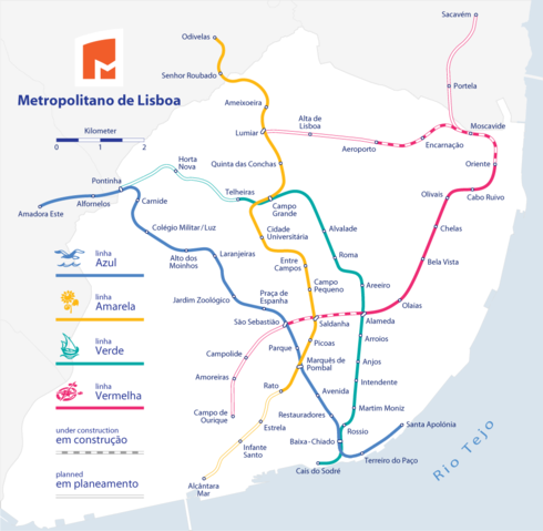
Image:Metro Lisboa Route Map.png
From Wikipedia, the free encyclopedia
Size of this preview: 490 × 479 pixels
Full resolution (978 × 957 pixels, file size: 117 KB, MIME type: image/png)
| |
This is a file from the Wikimedia Commons. The description on its description page there is shown below. |
| Description |
|
|||
|---|---|---|---|---|
| Source |
Self made, using the information from and using the following logos: Created with Adobe Illustrator 12.0 If you ask for, I will give you the .ai-file or I'll correct it or create other language versions. |
|||
| Date |
June 2007 |
|||
| Author |
Maximilian Dörrbecker ( Chumwa) |
|||
| Permission ( Reusing this image) |
Sie dürfen das Bild zu den folgenden Bedingungen nutzen:
|
|||
| Other versions |
|
File history
Click on a date/time to view the file as it appeared at that time.
| Date/Time | Dimensions | User | Comment | |
|---|---|---|---|---|
| current | 23:24, 25 December 2007 | 978×957 (117 KB) | Javitomad | (Nova ampliação da linha azul. (Bem feita já)) |
| 23:15, 25 December 2007 | 978×957 (117 KB) | Javitomad | (Nova ampliação da linha azul. (Bem feita já)) | |
| 23:09, 25 December 2007 | 978×957 (117 KB) | Javitomad | (Nova ampliação da linha azul. (Bem feita)) | |
| 22:58, 25 December 2007 | 978×957 (117 KB) | Javitomad | (Nova ampliação da linha azul.) | |
| 18:18, 30 June 2007 | 978×957 (150 KB) | Chumwa | (Maßstabsleiste und kommunale Grenzen hinzugefügt.) | |
| 04:53, 30 June 2007 | 1,307×1,274 (180 KB) | Chumwa | ({{Information |Description= *{{ de }} Streckennetz der Metro Lissabon *{{ en }} Metro Lisboa Route Map |Source=Self made, using the information from * de:Metro Lissabon * [http://www.carris.pt/downloads/planta_lx.jpg http://www.carris.pt] * [http://w) |
File links
The following pages on Schools Wikipedia link to this image (list may be incomplete):