Image:Portugal Império total.png
From Wikipedia, the free encyclopedia
Size of this preview: 640 × 281 pixels
Full resolution (1,425 × 625 pixels, file size: 43 KB, MIME type: image/png)
| |
This is a file from the Wikimedia Commons. The description on its description page there is shown below. |
 |
This map image should be recreated using vector graphics as an SVG file. This has several advantages; see Commons:Media for cleanup for more information. If an SVG form of this image is already available, please upload it. After uploading an SVG, replace this template with {{ vector version available|new image name.svg}}. |
|
العربية | Български | Català | Česky | Dansk | Deutsch | English | Esperanto | Español | Français | Galego | 한국어 | Italiano | Magyar | Lietuvių | Nederlands | 日本語 | Polski | Português | Română | Русский | Suomi | Svenska | Türkçe | Українська | 中文(繁體) | 中文(简体) | +/- |
|
Beschreibung
| Description |
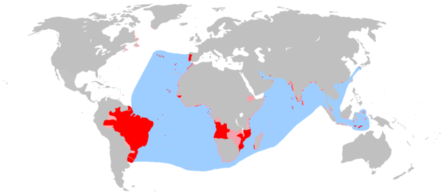
English: An anachronous map of the en:Portuguese Empire (1415-1999). Red - actual possessions; Pink - explorations, areas of influence and trade and claims of sovereignty; Blue - main sea explorations, routes and areas of inluence.
한국어: ko:포르투갈 제국(1415-1999)의 연대를 무시한 영역 지도. 빨강 - 실제 점유 영역; 분홍 - 탐사 지역, 교역과 영향이 있던 지역, 통치권이 주장되었던 지역; 파랑 - 주요 탐사, 무역 및 영향력을 끼쳤던 해역.
中文: 时间交错的葡萄牙帝国(1415年-1999年)地图,红色代表实际占有领土,粉红色代表勘探地、贸易影响地区以及宣称占有的陆域,蓝色代表勘探海域、航海路线和影响力所及的海域(不包括有争议的澳大利亚的发现)
en:Category:World maps |
|---|---|
| Source |
Originally from en.wikipedia; description page is/was here. |
| Date |
2007-03-30 (first version); 2007-04-16 (last version) |
| Author |
Original uploader was The Ogre at en.wikipedia Later versions were uploaded by The Red Hat of Pat Ferrick at en.wikipedia. |
| Permission ( Reusing this image) |
Released into the public domain (by the author).
|
License information
 |
This image has been (or is hereby) released into the public domain by its author, The Ogre at the wikipedia project. This applies worldwide. In case this is not legally possible: |
Original upload log
(All user names refer to en.wikipedia)
- 2007-04-16 16:58 The Ogre 1425×625×8 (44511 bytes) corrected map regarding Formosa/Taywan
- 2007-04-15 13:11 The Ogre 1425×625×8 (44415 bytes) rm question smarks in North America as per talk in [[Talk:Portuguese_Empire#An_exploration_.3D_Empire.3F|Talk:Portuguese Empire # An exploration = Empire?]]
- 2007-04-09 20:29 The Ogre 1425×625×8 (44551 bytes) An anachronous map of the [[Portuguese Empire]] (1415-1999). Red - actual possessions; Pink - explorations, areas of influence and claims of sovereignty; Blue - main sea explorations, routes and areas of inluence.
- 2007-04-03 23:35 The Red Hat of Pat Ferrick 1425×625×8 (29727 bytes) Removed Australia as per talk page.
- 2007-04-03 15:20 The Ogre 1425×625×8 (44746 bytes) I made this, again and again... It´s a work in progress! Just corrected the colour (red to Pink) for the [[Banda Islands]]
- 2007-03-31 16:02 The Ogre 1425×625×8 (44736 bytes) Again me, some minor tweaks.
- 2007-03-31 12:59 The Ogre 1425×625×8 (43961 bytes) I made this, once more! Adding Portuguese area of influence in the [[Kingdom of Kongo]]
- 2007-03-30 17:55 The Ogre 1425×625×8 (43701 bytes) I made this, again!
- 2007-03-30 17:42 The Ogre 1425×625×8 (43664 bytes) I made this!
Licensing
| |
The copyright holder of this work allows anyone to use it for any purpose including unrestricted redistribution, commercial use, and modification. Note: العربية | Asturianu | Български | Česky | Dansk | Deutsch | English | Esperanto | Español | فارسی | Français | Galego | Italiano | 日本語 | 한국어 | Kurdî / كوردی | Nederlands | Polski | Português | Русский | Suomi | Svenska | Türkçe | 中文(简体) | 中文(繁體) | 粵語 | +/- |
File history
Click on a date/time to view the file as it appeared at that time.
| Date/Time | Dimensions | User | Comment | |
|---|---|---|---|---|
| current | 11:42, 6 June 2007 | 1,425×625 (43 KB) | CedricBLN | ({{Information |Description=An anachronous map of the en:Portuguese Empire (1415-1999). Red - actual possessions; Pink - explorations, areas of influence and trade and claims of sovereignty; Blue - main sea explorations, routes and areas of inluence. ) |