Image:Ethnographic Iberia 200 BCE.PNG
From Wikipedia, the free encyclopedia
Size of this preview: 515 × 479 pixels
Full resolution (677 × 630 pixels, file size: 44 KB, MIME type: image/png)
| |
This is a file from the Wikimedia Commons. The description on its description page there is shown below. |
Summary
 |
This map image should be recreated using vector graphics as an SVG file. This has several advantages; see Commons:Media for cleanup for more information. If an SVG form of this image is already available, please upload it. After uploading an SVG, replace this template with {{ vector version available|new image name.svg}}. |
|
العربية | Български | Català | Česky | Dansk | Deutsch | English | Esperanto | Español | Français | Galego | 한국어 | Italiano | Magyar | Lietuvių | Nederlands | 日本語 | Polski | Português | Română | Русский | Suomi | Svenska | Türkçe | Українська | 中文(繁體) | 中文(简体) | +/- |
|
| Description |
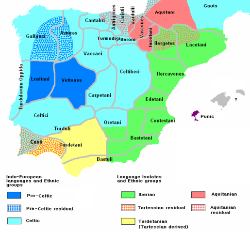
Ethnographic and Linguistic Map of the Iberian Peninsula at about 200 BCE (at the end of the Second Punic War). Based on the map done by Portuguese Archeologist Luís Fraga (luisfraga@arqueotavira.com), from the "Campo Arqueológico de Tavira" (Tavira Archeological Camp - official site), in Tavira, Algarve - Portugal. The reference map can be found at this location, and a pdf version, with extensive and detailed information on the criteria used, as well as the long bibliography used to source the map can be found here. |
|---|---|
| Source |
self-made from Image:Blank-peninsula Iberica.png |
| Date |
28 February 2008 |
| Author |
The Ogre |
| Permission ( Reusing this image) |
see below
|
Licensing
|

File history
Click on a date/time to view the file as it appeared at that time.
| Date/Time | Dimensions | User | Comment | |
|---|---|---|---|---|
| current | 07:11, 9 March 2008 | 677×630 (44 KB) | The Ogre | (Still another correction for the Baleares) |
| 11:51, 8 March 2008 | 677×630 (44 KB) | The Ogre | (Small corrections) | |
| 07:05, 29 February 2008 | 677×630 (43 KB) | The Ogre | (Fixed minor graphical tweak) | |
| 10:33, 28 February 2008 | 677×630 (43 KB) | The Ogre | (Changed Proto-Celtic to Pre-Celtic and increased the area for the Aquitanian language) | |
| 04:46, 28 February 2008 | 677×630 (43 KB) | The Ogre | ({{Information |Description=Ethnographic and Linguistic Map of the Iberian Peninsula at about 200 BCE (at the end of the Second Punic War). Based on the map done by Portuguese Archeologist Luís Fraga (luis) |