Image:Hannibal route of invasion.gif
From Wikipedia, the free encyclopedia
Size of this preview: 634 × 479 pixels
Full resolution (1,280 × 968 pixels, file size: 114 KB, MIME type: image/gif)
| |
This is a file from the Wikimedia Commons. The description on its description page there is shown below. |
| Description |
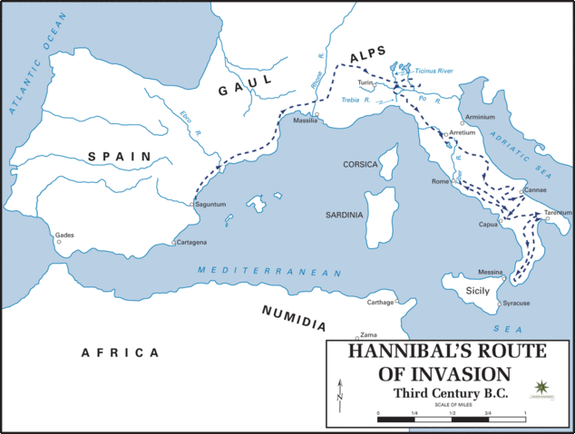
Hannibal's route of invasion |
|---|---|
| Source |
The Department of History, United States Military Academy |
| Date |
- |
| Author |
Frank Martini. Cartographer, Department of History, United States Military Academy |
| Permission ( Reusing this image) |
Quotation of the permission Frank Martini gave me after my ask for permission to use "The Department of History, United States Military Academy" contents in the Wikipedia: Tony, The maps found on the web site may be used for the purposes stated below. We would kindly ask that credit be given to "The Department of History, United States Military Academy." If you reguire higher resolution images suggest you contact one od the sources cited on our site. Best of luck with the project. Frank Martini Cartographer, Department of History United States Military Academy |
| Other versions |  |
 |
This image was (or all images in this article or category were) uploaded in the GIF format, while a different format would have been more suitable. Commons discourages the use of GIF files, except for animations. See Commons:File types for more information. If possible, please upload a PNG version (or JPEG for some photos) of this image, and mark the GIF image as {{ superseded|Image:new image name}}. If you like, encourage other Wikimedia projects using the GIF to use the new version instead. If this image is a diagram or other image suitable for vectorisation, please tag this image with {{ convert to SVG}} instead of {{ badGIF}}. If not suitable for vectorisation, use {{ convert to PNG}}. English | Español | Français | Português | +/- |
 |
Permission is granted to copy, distribute and/or modify this document under the terms of the GNU Free Documentation license, Version 1.2 or any later version published by the Free Software Foundation; with no Invariant Sections, no Front-Cover Texts, and no Back-Cover Texts. A copy of the license is included in the section entitled " GNU Free Documentation license". Aragonés | العربية | Asturianu | Беларуская (тарашкевіца) | Български | বাংলা | ইমার ঠার/বিষ্ণুপ্রিয়া মণিপুরী | Brezhoneg | Bosanski | Català | Cebuano | Česky | Dansk | Deutsch | Ελληνικά | English | Esperanto | Español | Eesti | Euskara | فارسی | Suomi | Français | Gaeilge | Galego | עברית | Hrvatski | Magyar | Bahasa Indonesia | Ido | Íslenska | Italiano | 日本語 | ქართული | ភាសាខ្មែរ | 한국어 | Kurdî / كوردی | Latina | Lëtzebuergesch | Lietuvių | Bahasa Melayu | Nnapulitano | Nederlands | Norsk (nynorsk) | Norsk (bokmål) | Occitan | Polski | Português | Română | Русский | Slovenčina | Slovenščina | Shqip | Српски / Srpski | Svenska | తెలుగు | ไทย | Tagalog | Türkçe | Українська | اردو | Tiếng Việt | Volapük | Yorùbá | 中文(简体) | 中文(繁體) | +/- |
File history
Click on a date/time to view the file as it appeared at that time.
| Date/Time | Dimensions | User | Comment | |
|---|---|---|---|---|
| current | 23:17, 17 March 2006 | 1,280×968 (114 KB) | GhePeU | |
| 21:20, 9 July 2005 | 740×560 (34 KB) | Redtony | ({{Information| Description = Hannibal's route of invasion |Date = - |Author = Frank Martini. Cartographer, Department of History, United States Military Academy |Source = The Department of History, United States Military Academy [http://www.dean.usma.edu/) |