Image:Deutschland Besatzungszonen - 1945 1946.svg

From Wikipedia, the free encyclopedia

Deutschland_Besatzungszonen_-_1945_1946.svg‎ (SVG file, nominally 650 × 830 pixels, file size: 225 KB)

Wikimedia Commons logo This is a file from the Wikimedia Commons. The description on its description page there is shown below.
Commons is a freely licensed media file repository. You can help.
Description
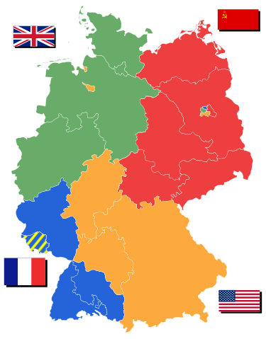
English: Allied occupation zones in Germany after 02/21/1947 after Lippe became part of Northrhine-Westphalia
Deutsch: Alliierte Besatzungszonen Deutschlands nachdem Lippe zu NRW am 21. Januar 1947 beigetreten ist. mit Länder
Nederlands: Geallieerde bezettingszones in Duitsland na 22.01.1947 met deelstaten
Source

Based on Image:Deutschland Besatzungszonen 1945 1946.png and Image:Karte Deutsche Bundesländer (nummeriert).svg

Date

16 April

Author

User:52 Pickup

Permission
( Reusing this image)
Creative Commons License
Creative Commons Attribution icon Creative Commons Share Alike icon
This file is licensed under the Creative Commons Attribution ShareAlike 2.5 License. In short: you are free to share and make derivative works of the file under the conditions that you appropriately attribute it, and that you distribute it only under a license identical to this one. Official license

NOTE: "subject to disclaimers" below may not actually apply, this was tagged with {{ GFDL-user-en}}, and after May 2007, w:en:Template:GFDL-self did not require disclaimers. Please check the image description page on the English Wikipedia (or, if it has been deleted, ask an English Wikipedia administrator). See Wikipedia:GFDL standardization for details.

52 Pickup at the English language Wikipedia, the copyright holder of this work, has published or hereby publishes it under the following license:
GNU head Permission is granted to copy, distribute and/or modify this document under the terms of the GNU Free Documentation License, Version 1.2 or any later version published by the Free Software Foundation; with no Invariant Sections, no Front-Cover Texts, and no Back-Cover Texts.
Subject to disclaimers.

Asturianu | Български | Català | Deutsch | English | Español | Français | Gaeilge | Italiano | Polski | Português | +/-

Note: This tag should not be used. For images that were released on the English Wikipedia using either GFDL or GFDL-self with disclaimers, use {{ GFDL-user-en-with-disclaimers}}. For images without disclaimers please use {{ GFDL-user-en-no-disclaimers}} instead. If you are the copyright holder of files that were released on Wikipedia consider removing the disclaimers.


File history

Click on a date/time to view the file as it appeared at that time.

Date/Time Dimensions User Comment
current 19:37, 22 July 2008 650×830 (225 KB) 52 Pickup (Corrected assignment of Lindau)
11:39, 7 May 2007 650×830 (225 KB) 52 Pickup (with corrected borders for eastern states)
18:27, 16 April 2007 650×830 (224 KB) 52 Pickup (damn, uploaded the wrong file first time)
18:21, 16 April 2007 744×1,052 (1.13 MB) 52 Pickup ({{Information |Description= {{en|Allied occupation zones in Germany 1945/1946 with states}} {{de|Allierte Besatzungszonen Deutschlands 1945/1946 mit Länder}} {{nl|Geallieerde bezettingszones in Duitsland 1945/1946 met deelstaten}} |Source= Based on [[Ima)
The following pages on Schools Wikipedia link to this image (list may be incomplete):
The Schools Wikipedia is sponsored by SOS Children , and consists of a hand selection from the English Wikipedia articles with only minor deletions (see www.wikipedia.org for details of authors and sources). See also our Disclaimer.