Image:Map-DR-Prussia.svg
From Wikipedia, the free encyclopedia
Map-DR-Prussia.svg (SVG file, nominally 2,621 × 2,224 pixels, file size: 712 KB)
| |
This is a file from the Wikimedia Commons. The description on its description page there is shown below. |
| Description |
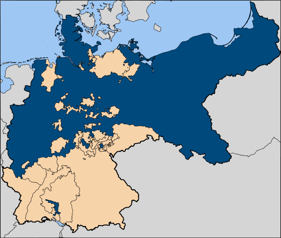
The Kingdom of Prussia within the German Empire |
||
|---|---|---|---|
| Source |
Based on map data of the IEG-Maps project (Andreas Kunz, B. Johnen and Joachim Robert Moeschl: University of Mainz) - http://www.ieg-maps.uni-mainz.de |
||
| Date |
8 Nov 2006 |
||
| Author |
User:52 Pickup |
||
| Permission ( Reusing this image) |
|
File history
Click on a date/time to view the file as it appeared at that time.
| Date/Time | Dimensions | User | Comment | |
|---|---|---|---|---|
| current | 11:43, 11 January 2007 | 2,621×2,224 (712 KB) | 52 Pickup | (improved colour scheme) |
| 12:30, 7 December 2006 | 2,621×2,224 (712 KB) | 52 Pickup | ||
| 17:52, 29 November 2006 | 2,621×2,224 (1.05 MB) | Bonas | ({{Information |Description=The Kingdom of Prussia within the German Empire |Source= Image:Map-DR-Prussia.svg, map data from the IEG-Maps project by Andreas Kunz, B. Johnen an) |
File links
The following pages on Schools Wikipedia link to this image (list may be incomplete):