Image:Kosovo municipalities.svg

From Wikipedia, the free encyclopedia

Kosovo_municipalities.svg‎ (SVG file, nominally 267 × 292 pixels, file size: 299 KB)

Wikimedia Commons logo This is a file from the Wikimedia Commons. The description on its description page there is shown below.
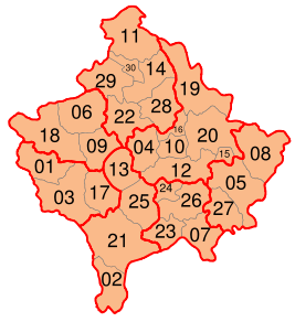
Commons is a freely licensed media file repository. You can help.

Summary

Description

Numbered map of the municipalities of Kosovo, also showing the district divisions

Source

Image:Kosovo admin.svg Image:Kosovo municipalities.PNG

Date

20080226

Author

Jackaranga

Permission
( Reusing this image)

see below


Licensing

I, the copyright holder of this work, hereby publish it under the following licenses:
GNU head Permission is granted to copy, distribute and/or modify this document under the terms of the GNU Free Documentation license, Version 1.2 or any later version published by the Free Software Foundation; with no Invariant Sections, no Front-Cover Texts, and no Back-Cover Texts. A copy of the license is included in the section entitled " GNU Free Documentation license".

Aragonés | العربية | Asturianu | Беларуская (тарашкевіца) | Български | বাংলা | ইমার ঠার/বিষ্ণুপ্রিয়া মণিপুরী | Brezhoneg | Bosanski | Català | Cebuano | Česky | Dansk | Deutsch | Ελληνικά | English | Esperanto | Español | Eesti | Euskara | فارسی | Suomi | Français | Gaeilge | Galego | עברית | Hrvatski | Magyar | Bahasa Indonesia | Ido | Íslenska | Italiano | 日本語 | ქართული | ភាសាខ្មែរ | 한국어 | Kurdî / كوردی | Latina | Lëtzebuergesch | Lietuvių | Bahasa Melayu | Nnapulitano | Nederlands | ‪Norsk (nynorsk)‬ | ‪Norsk (bokmål)‬ | Occitan | Polski | Português | Română | Русский | Slovenčina | Slovenščina | Shqip | Српски / Srpski | Svenska | తెలుగు | ไทย | Tagalog | Türkçe | Українська | اردو | Tiếng Việt | Volapük | Yorùbá | ‪中文(简体)‬ | ‪中文(繁體)‬ | +/-

Some rights reserved
Creative Commons Attribution icon Creative Commons Share Alike icon
This file is licensed under the Creative Commons Attribution ShareAlike license versions 3.0, 2.5, 2.0, and 1.0

Български | Català | Česky | Dansk | Deutsch | Ελληνικά | English | Español | Euskara | Estremeñu | Français | עברית | Italiano | 日本語 | 한국어 | Lietuvių | Nederlands | ‪Norsk (bokmål)‬  | Occitan | Polski | Piemontèis | Português | Русский | 中文 | +/-

You may select the license of your choice.

File history

Click on a date/time to view the file as it appeared at that time.

Date/Time Dimensions User Comment
current 14:35, 28 February 2008 267×292 (299 KB) Future Perfect at Sunrise (fix numbering)
20:43, 27 February 2008 267×292 (300 KB) Jackaranga (removed labels for districts)
20:33, 27 February 2008 630×490 (302 KB) Jackaranga (colours + typo)
15:22, 26 February 2008 630×490 (302 KB) Jackaranga (hiding the labels in a manner mediawiki understands I hope)
15:20, 26 February 2008 630×490 (302 KB) Jackaranga ({{Information |Description= Numbered map of the municipalities of Kosovo, also showing the district devisions (+ hidden layer with district names that can be switched on in Inkscape if needed) |Source= Image:Kosovo admin.svg [[:Image:Kosovo municipal)
The following pages on Schools Wikipedia link to this image (list may be incomplete):
This Wikipedia DVD Selection was sponsored by a UK Children's Charity, SOS Children UK , and consists of a hand selection from the English Wikipedia articles with only minor deletions (see www.wikipedia.org for details of authors and sources). See also our Disclaimer.