Image:IDH Santiago.svg
From Wikipedia, the free encyclopedia
IDH_Santiago.svg (SVG file, nominally 600 × 600 pixels, file size: 61 KB)
| |
This is a file from the Wikimedia Commons. The description on its description page there is shown below. |
| Description |
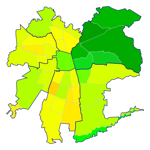
Español: Mapa de las comunas de Santiago de Chile según su Índice de Desarrollo Humano (2006). Además, se agrupan por sectores geográficos (Centro, Nororiente, Suroriente, Sur, Surponiente, Norponiente, Norte).
██ 0,950 ██ 0,900 ██ 0,850 ██ 0,800 ██ 0,750 ██ 0,700 ██ 0,650 ██ 0,600 |
|||
|---|---|---|---|---|
| Source |
Mapa obtenido de Image:Comunas de Santiago.svg. Datos obtenidos de Las trayectorias del Desarrollo Humano en las comunas de Chile (1994-2003) (PNUD y Gobierno de Chile) |
|||
| Date |
19 de agosto de 2007 |
|||
| Author |
B1mbo |
|||
| Permission ( Reusing this image) |
|
| |
Legal disclaimer The edition and circulation of maps, geographic charts and other documents about the boundaries and frontiers of Chile, don't have any relation with the Republic of Chile, according to the Article 2 g) of DFL Nº83 of 1979 of the Ministery of Foreign Affairs. La edición y circulación de mapas, cartas geográficas y otros documentos sobre los límites y fronteras de Chile no tienen relación alguna con la República de Chile de acuerdo al artículo 2 g) del DFL Nº83 de 1979 del Ministerio de Relaciones Exteriores. |
File history
Click on a date/time to view the file as it appeared at that time.
| Date/Time | Dimensions | User | Comment | |
|---|---|---|---|---|
| current | 02:56, 20 August 2007 | 600×600 (61 KB) | B1mbo | ({{Information |Description={{es|Mapa de las comunas de Santiago de Chile según su Índice de Desarrollo Humano (2006). Además, se agrupan por sectores geográficos (Centro, Nororiente, Suroriente, Sur, Surponiente, Norponiente, Norte). {{legend|#00A) |