Image:Plan de la Ville de Santiago.jpg
From Wikipedia, the free encyclopedia
Size of this preview: 640 × 448 pixels
Full resolution (650 × 455 pixels, file size: 112 KB, MIME type: image/jpeg)
| |
This is a file from the Wikimedia Commons. The description on its description page there is shown below. |
Sumario
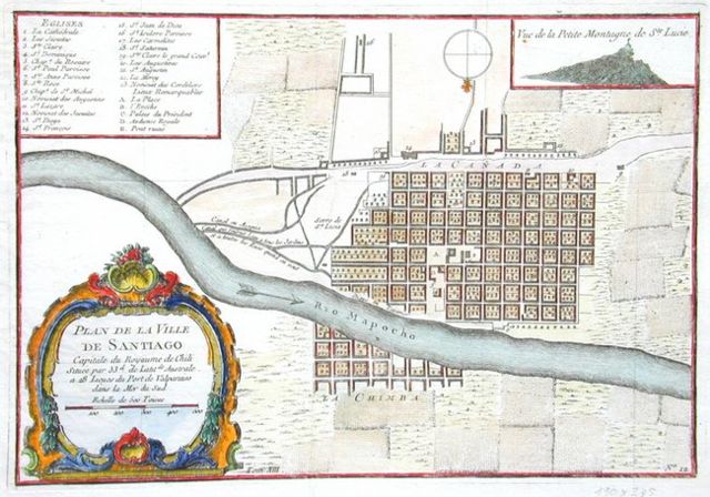
| Description |
Español: Plan de la ville de Santiago, mapa de Santiago de Chile durante el siglo XVIII. En la esquina inferior dice:
Plan de la Ville de Santiago |
|---|---|
| Source |
Antique Books Maps: Maps - Chile |
| Date |
1712, colour in 1756 |
| Author |
François Frezier / Jacques N. Bellin |
| Permission ( Reusing this image) |
PD-old |
| Other versions | Image:Pianta della Citta di Sant'Iago Capitale del regno del Chili.jpg |
Licensing
This photographic reproduction is therefore also in the public domain. العربية | Česky | Deutsch | English | Ελληνικά | Español | فارسی | Français | עברית | Bahasa Indonesia | Italiano | 日本語 | 한국어 | Magyar | Nederlands | Polski | Português | Română | Русский | Slovenščina | Српски / Srpski | Basa Sunda | Türkçe | Українська | 中文(繁體) | 中文(简体) | +/- |

File history
Click on a date/time to view the file as it appeared at that time.
| Date/Time | Dimensions | User | Comment | |
|---|---|---|---|---|
| current | 21:13, 6 May 2007 | 650×455 (112 KB) | B1mbo | ({{Information |Description={{es|''Plan de la ville de Santiago'', mapa de Santiago de Chile durante el siglo XVI. En la esquina inferior dice: ''Plan de la Ville de Santiago<br/>Capitale du Royaume de Chili<br/>Située par 33<sup>d.</sup> de Latit <s) |
File links
Metadata
This file contains additional information, probably added from the digital camera or scanner used to create or digitize it. If the file has been modified from its original state, some details may not fully reflect the modified file.
| Exposure time | 222298112/3 sec (74099370.666667) |
|---|---|
| F-number | f/74099370.666667 |
| Lens focal length | 74099370.666667 mm |
| Image title | IF |
| Horizontal resolution | 0.27359172533345 dpi |
| Vertical resolution | 21.564351931118 dpi |
| File change date and time | Photoshop 7.0 |
| Y and C positioning | 2 |
| Exposure Program | Normal program |
| Exif version | 2.1 |
| Image compression mode | 256.00001519914 |
| Shutter speed | 0.99999677414165 |
| Aperture | 0.66742772991023 |
| Brightness | 5.3542653189765 |
| Exposure bias | 74099374.733333 |
| Maximum land aperture | 74099370.666667 |
| Subject distance | 74099370.666667 metres |
| Metering mode | Pattern |
| Light source | Unknown |
| Flash | 0 |
| Colour space | sRGB |
| Focal plane Y resolution | 74099373.266667 |
| Focal plane resolution unit | 0 |
| Exposure index | 0.92657341498712 |
| Sensing method | 0 |