Image:Three Kingdoms of Korea Map.png
From Wikipedia, the free encyclopedia
Size of this preview: 381 × 479 pixels
Full resolution (658 × 827 pixels, file size: 15 KB, MIME type: image/png)
| |
This is a file from the Wikimedia Commons. The description on its description page there is shown below. |
|
|
The neutrality of this article is disputed. Please see the discussion on the talk page. (December 2007) Please do not remove this message until the dispute is resolved. |
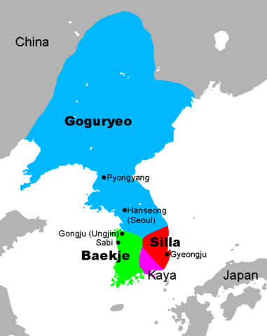
Map of the Three Kingdoms of Korea, at the end of the 5th century, with the largest expansion of Goguryeo. Hanseong was initially the capital of Baekje. Note that the spellings of the countries and cities may differ significantly in different sources.
Map data from , which is GFDL, modified and map creation by Chris 73.
- Extra borders removed by Kooo.
- See also: Image:Three Kingdoms of Korea blank.png for a blank map.
- The source file is an open office.org file Image:Three Kingdoms of Korea Map.sxd
Used in:
| Licensing: This image was created by Chris 73. The image is licensed under a dual license; please choose either of the two licenses below as desired. Attribution to Wikipedia or another project of the Wikimedia foundation is required for both licenses if the image is used outside of projects of the Wikimedia foundation. Attribution to me is not required.
"I want to use the image. How do I do that?" You can use this image freely for any purpose, including commercial use, provided that you license it under one of the above licenses. My suggestion is to use the following text:
For privacy reasons please use only "Chris 73" as author. If necessary, please translate the text in your language. For electronic use please include the links in the text as shown, for printed use please print the text as shown. If you use the image I would appreciate it if you would let me know on my talk page, but this is not required as long as you follow one of the above licenses. |
|

File history
Click on a date/time to view the file as it appeared at that time.
| Date/Time | Dimensions | User | Comment | |
|---|---|---|---|---|
| current | 02:41, 16 January 2008 | 658×827 (15 KB) | Cydevil38 | (Reverted to version as of 09:01, 5 November 2004) |
| 06:32, 24 December 2007 | 658×827 (17 KB) | Shibo77 | ||
| 09:01, 5 November 2004 | 658×827 (15 KB) | Kooo | (Removed extra borders.) | |
| 05:49, 4 November 2004 | 686×830 (16 KB) | Chris 73 | (Three Kingdoms of Korea map) |