Image:Locationmap Korea.png
From Wikipedia, the free encyclopedia
No higher resolution available.
Locationmap_Korea.png (250 × 115 pixels, file size: 5 KB, MIME type: image/png)
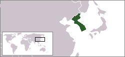
This map shows the location of the Korean peninsula.
This map was created using the existing Image:LocationSouthKorea.png contributed by User:Vardion.
| |
Permission is granted to copy, distribute and/or modify this document under the terms of the GNU Free Documentation License, Version 1.2 or any later version published by the Free Software Foundation; with no Invariant Sections, no Front-Cover Texts, and no Back-Cover Texts. Subject to disclaimers. |
Media:ngj
|
|
The Wikimedia Commons has another file with the same name as this file. To include the Commons media file in Wikipedia, this locally stored file needs to be renamed. | |
File history
Click on a date/time to view the file as it appeared at that time.
| Date/Time | Dimensions | User | Comment | |
|---|---|---|---|---|
| current | 02:50, 20 July 2007 | 250×115 (5 KB) | IAMTHEEGGMAN ( Talk | contribs) | (Updated to borders at the time...) |
| revert | 18:18, 16 August 2004 | 250×115 (4 KB) | Kokiri ( Talk | contribs) | (map showing location of the Korean peninsula) |
See the setup instructions for more information.
File links
The following pages on Schools Wikipedia link to this image (list may be incomplete):