Image:Tasmanmap1644.jpg
From Wikipedia, the free encyclopedia
Size of this preview: 640 × 480 pixels
Full resolution (4,000 × 3,000 pixels, file size: 1.2 MB, MIME type: image/jpeg)
| |
This is a file from the Wikimedia Commons. The description on its description page there is shown below. |
Contents |
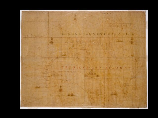
Title
Carten - Dese landen Zin ontdeckt bij de compangie ontdeckers behaluen het norder deelt van noua guina ende het West Eynde van Java dit Warck aldus bij mallecanderen geuoecht ut verscheijden schriften als mede ut eijgen beuinding bij abel Jansen Tasman. Ano 1644 dat door order van de E.d.hr. gouuerneur general Anthonio van diemens
Title translated
Map - These lands were discovered by the Company's explorers except for the northern part of New Guinea and the west end of Java. This work thus put together from different writings as well as from personal observation by Abel Jansen Tasman, A.D. 1644, by order of His Excellency the Governor-General Antonio van Diemen.
Also known as
Bonaparte Tasman map; Tasman map 1644.
Notes
100 German or geographical miles on the graphic scale measures 6,8 cm.; 15 German miles equals one degree of latitude.
Ornate manuscript map on Japanese paper bought in 1891 by Prince Roland Bonaparte, and presented to the Mitchell Library by the Princess George of Greece in 1931.
Now thought to be neither by Tasman nor from 1644, this map is important for being the only first-hand record of Tasman's route in 1644.
Includes inset with Mauritius, Java and Sumatra on scale ca. 1:21 568 600 showing the course of the Heemskerck and the Zeehaen in 1642 from Batavia to Mauritius and further south.
Also available in a digitised form via the Internet at http://image.sl.nsw.gov.au/cgi-bin/ebindshow.pl?doc=crux/a127;seq=35
This item has been included in the Nelson Meers Foundation Benefaction, 2003.
Licensing
 |
This image (or other media file) is in the public domain because its copyright has expired. This applies to the United States, Canada, the European Union and those countries with a copyright term of life of the author plus 70 years. العربية | Asturianu | Български | Català | Česky | Dansk | Deutsch | English | Ελληνικά | Esperanto | Español | Euskara | فارسی | Français | Gaeilge | Galego | עברית | हिन्दी | Bahasa Indonesia | Italiano | 日本語 | 한국어 | Kurdî / كوردی | Lietuvių | Magyar | Nederlands | Norsk (nynorsk) | Македонски | Bahasa Melayu | Polski | Português | Română | Русский | Slovenčina | Slovenščina | Shqip | Suomi | Sámegiella | Türkçe | 中文(简体) | 中文(繁體) | 粵語 | +/- |
File history
Click on a date/time to view the file as it appeared at that time.
| Date/Time | Dimensions | User | Comment | |
|---|---|---|---|---|
| current | 15:53, 5 April 2006 | 4,000×3,000 (1.2 MB) | Harmsma | (Title Carten dese landen Zin ontdeckt bij de compangie ontdeckers behaluen het norder deelt van noua guina ende het West Eynde van Java dit Warck aldus bij mallecanderen geuoecht ut verscheijden schriften als mede ut eijgen beuinding bij abel Jansen Tasm) |