Image:France departements regions narrow.jpg
From Wikipedia, the free encyclopedia
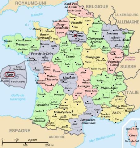
Size of this preview: 453 × 479 pixels
Full resolution (520 × 550 pixels, file size: 68 KB, MIME type: image/jpeg)
| |
This is a file from the Wikimedia Commons. The description on its description page there is shown below. |
| Description |
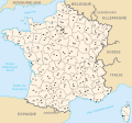
Map of official départements and régions of France, with French titles (in JPEG format for larger, rapid display: 5x faster than SVG). French: Départements et régions, en Francais. |
||
|---|---|---|---|
| Source |
Image:Départements+régions (France).svg (Wikimedia file, converted to quick JPEG and narrowed 15%) |
||
| Date |
21-March-2007 |
||
| Author |
self (after User:Historicair 6-Nov-2006) |
||
| Permission ( Reusing this image) |
|
||
| Other versions | Wider view, large 254kb SVG file: Image:Départements+régions (France).svg |

 A vector version of this image (SVG) is available. For more information about vector graphics, read about Commons transition to SVG. Deutsch | English | Español | Français | Galego | עברית | Magyar | Italiano | 日本語 | 한국어 | Lietuvių | Polski | Português | Русский | Српски / Srpski | Українська | +/- |
 |
Variations
 CURRENT IMAGE: Départements 520px (15% magnified, rapid JPEG format) |
 Départements 588px (régions en lettres et colorisé, wider view, same labels, SVG format 5x slower) |
 Départements sans colorisé (numeric labels, uncolorized) |
 Départements de France avec un découpage régional |
File history
Click on a date/time to view the file as it appeared at that time.
| Date/Time | Dimensions | User | Comment | |
|---|---|---|---|---|
| current | 13:44, 21 March 2007 | 520×550 (68 KB) | Wikid77 | (Circled Paris in maroon red colour, to tie inset to Paris region.) |
| 12:02, 21 March 2007 | 520×550 (68 KB) | Wikid77 | ({{Information |Description=Map of official départements and régions of France, with French titles (in JPEG format for larger, rapid display: 5x faster than SVG). ''French:'' Départements et régions, en Francais. |Source=[[:Image:Départements+région) |