Image:Adelaide metropolitan area map.svg
From Wikipedia, the free encyclopedia
Adelaide_metropolitan_area_map.svg (SVG file, nominally 974 × 2,373 pixels, file size: 331 KB)
| |
This is a file from the Wikimedia Commons. The description on its description page there is shown below. |
Summary
| Description |
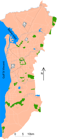
Map of Adelaide Shows major roads (per gregory's 2004 street directory), airports (adelaide, parafield and edinburgh airforce base) and all public reserves or parks > about 130 acres. Council district maps dated from 2004->2007 used to determine the landward boundary |
|---|---|
| Source |
self-made |
| Date |
2007-10-23 |
| Author |
Peripitus |
| Permission ( Reusing this image) |
see below
|
Licensing
|

File history
Click on a date/time to view the file as it appeared at that time.
| Date/Time | Dimensions | User | Comment | |
|---|---|---|---|---|
| current | 02:45, 3 November 2007 | 974×2,373 (331 KB) | Peripitus | ({{Information |Description=Map of Adelaide Shows major roads (per gregory's 2004 street directory), airports (adelaide, parafield and edinburgh airforce base) and all public reserves or parks > about 130 acres. Council district maps dated from 2004->2007 ) |
| 09:13, 24 October 2007 | 974×2,373 (136 KB) | Peripitus | ({{Information |Description=Map of Adelaide Shows major roads (per gregory's 2004 street directory), airports (adelaide, parafield and edinburgh airforce base) and all public reserves or parks > about 130 acres. Council district maps dated from 2004->2007 ) | |
| 21:32, 23 October 2007 | 487×1,188 (144 KB) | Peripitus | ({{Information |Description=Map of Adelaide Shows major roads (per gregory's 2004 street directory), airports (adelaide, parafield and edinburgh airforce base) and all public reserves or parks > about 130 acres. Council district maps dated from 2004->2007 ) | |
| 13:38, 23 October 2007 | 487×1,188 (145 KB) | Peripitus | ( {{Information |Description=Map of Adelaide Shows major roads (per gregory's 2004 street directory), airports (adelaide, parafield and edinburgh airforce base) and all public reserves or parks > about 130 acres. Council district maps dated from 2004->2007) | |
| 13:35, 23 October 2007 | 749×1,188 (145 KB) | Peripitus | (Reverted to version as of 13:26, 23 October 2007) | |
| 13:34, 23 October 2007 | 487×1,188 (166 KB) | Peripitus | ({{Information |Description=Map of Adelaide Shows major roads (per gregory's 2004 street directory), airports (adelaide, parafield and edinburgh airforce base) and all public reserves or parks > about 130 acres. Council district maps dated from 2004->2007 ) | |
| 13:26, 23 October 2007 | 749×1,188 (145 KB) | Peripitus | ({{Information |Description=Map of Adelaide Shows major roads (per gregory's 2004 street directory), airports (adelaide, parafield and edinburgh airforce base) and all public reserves or parks > about 130 acres. Council district maps dated from 2004->2007 ) |