Image:Italy 1000 AD.svg
From Wikipedia, the free encyclopedia
Italy_1000_AD.svg (SVG file, nominally 565 × 811 pixels, file size: 861 KB)
| |
This is a file from the Wikimedia Commons. The description on its description page there is shown below. |
Contents |
Summary
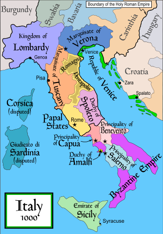
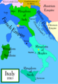
en: Political map of Italy in 1000 AD (CE). Created by MapMaster.
Part of a series of maps on the history of Italy:
 1084 AD |
 1494 AD |
 1796 AD |
 1810 AD |
Other versions
English
Italiano
Deutsch
Español
References
- Bjorklund, Oddvar; Holmboe, Haakon; Rohr, Anders (1970) Historical Atlas of the World, Barnes & Noble, NY, SBN: 389-00253-4. w:en:Holy Roman Empire
- A map from AttiliosThe Historical Atlas by William R. ShepherdHistorical Atlas, (1911).
In addition, a number of other sources were consulted in an effort to determine the following matters:
- The extent of Venetian control over the cities of Dalmatia such as Zara and Spalato. Although the Venetians had been pushed off the mainland earlier, in the period around the year 1000, the Venetians made an effort to recover these cities.
- The extent of Saracen control over Corsica and Sardinia. Information is sparse. The apparent situation is that the Muslims had several bases on the coasts of these islands, but did not control the countryside (such as they did in Sicily).
- Whether or not the principalities of Capua and Benevento were separate states in the year 1000. Based on lists of their rulers (various Pandulfs and Landulfs), the answer seems to be "yes".
- Who controlled the Balkans on the southeastern border of the Kingdom of Croatia. Candidates include Bulgaria, the Byzantine Empire, Croatia, and Serbia.
As noted, there is significant disagreement among sources on these questions.
This map was commissioned by Attilios, and there is also a discussion to be found on MapMaster's English talk page.
Licensing
|

File history
Click on a date/time to view the file as it appeared at that time.
| Date/Time | Dimensions | User | Comment | |
|---|---|---|---|---|
| current | 19:50, 17 April 2007 | 565×811 (861 KB) | MapMaster | (Some further changes) |
| 05:10, 19 February 2007 | 565×811 (824 KB) | MapMaster | (changes to ensure consistency with my other Italy maps) | |
| 05:39, 25 November 2006 | 565×811 (823 KB) | MapMaster | (Improved map.) | |
| 14:44, 18 November 2006 | 565×811 (827 KB) | MapMaster | (Improved (I hope) version based on recommendations from Attilios.) | |
| 21:50, 17 November 2006 | 565×811 (768 KB) | MapMaster | (Political map of Italy in 1000 AD (CE).) |