Image:Map Byzantine Empire 1045.svg
From Wikipedia, the free encyclopedia
Map_Byzantine_Empire_1045.svg (SVG file, nominally 1,300 × 900 pixels, file size: 329 KB)
Summary
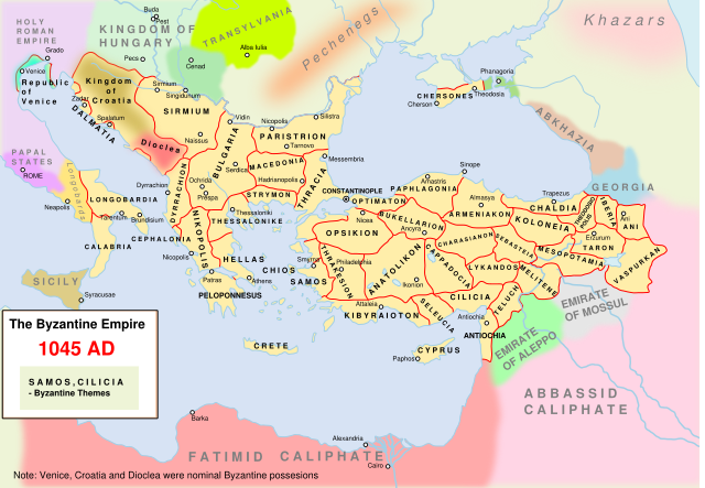
Own work. The Byzantine empire and its neighbours in 1045. Byzantine administrative divisions included.
Source> Stelian Brezeanu> O istorie a Imperiului Bizantin, Bucharest 1981. The map at page 110.
Please write on the talk page if I misspelled the name of some themes.
An available derivative work is a cropping showing only the central Balkans: Image:Byzantine Macedonia 1045CE.svg.
Licensing
|
File history
Click on a date/time to view the file as it appeared at that time.
| Date/Time | Dimensions | User | Comment | |
|---|---|---|---|---|
| current | 17:27, 5 May 2008 | 1,300×900 (329 KB) | Andrei nacu ( Talk | contribs) | |
| revert | 18:56, 23 February 2008 | 1,300×900 (316 KB) | Andrei nacu ( Talk | contribs) | |
| revert | 09:45, 11 December 2007 | 1,300×900 (315 KB) | Andrei nacu ( Talk | contribs) | |
| revert | 15:21, 10 December 2007 | 1,300×900 (315 KB) | Andrei nacu ( Talk | contribs) | |
| revert | 14:50, 10 December 2007 | 1,300×900 (314 KB) | Andrei nacu ( Talk | contribs) | |
| revert | 14:39, 10 December 2007 | 1,300×900 (312 KB) | Andrei nacu ( Talk | contribs) | |
| revert | 14:34, 10 December 2007 | 1,300×900 (311 KB) | Andrei nacu ( Talk | contribs) | (Own work. The Byzantine empire and its neighbours in 1045. Byzantine administrative divisions included.) |
See the setup instructions for more information.
File links
The following pages on Schools Wikipedia link to this image (list may be incomplete):
Categories: GFDL images | Cc-by-sa-3.0,2.5,2.0,1.0 images | Self-published work | Maps of the Byzantine Empire