Image:SFRYugoslaviaNumbered.png
From Wikipedia, the free encyclopedia
Size of this preview: 548 × 480 pixels
Full resolution (941 × 824 pixels, file size: 28 KB, MIME type: image/png)
| |
This is a file from the Wikimedia Commons. The description on its description page there is shown below. |
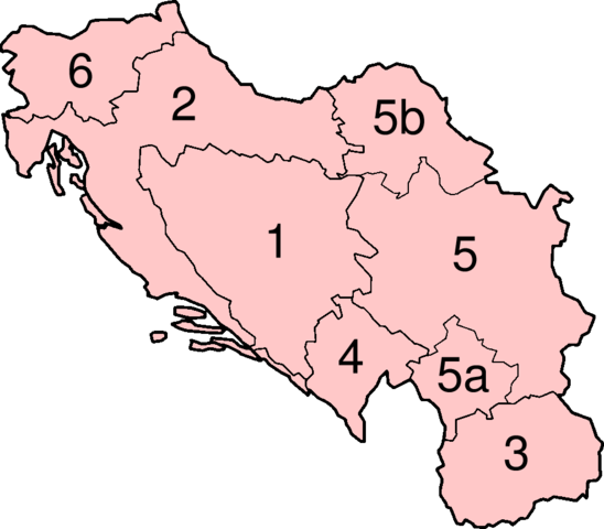
Numbered map of the Socialist Federal Republic of Yugoslavia.
- Socialist republic of Bosnia and Herzegovina, with capital in Sarajevo,
- Socialist republic of Croatia, with capital in Zagreb,
- Socialist republic of Macedonia, with capital in Skopje,
- Socialist republic of Montenegro, with capital in Titograd,
- Socialist republic of Serbia, with capital in Belgrade, which also contained:
5a. Socialist autonomous province of Kosovo, with capital in Priština
5b. Socialist autonomous province of Vojvodina, with capital in Novi Sad - Socialist republic of Slovenia, with capital in Ljubljana.
Licensing
 |
Permission is granted to copy, distribute and/or modify this document under the terms of the GNU Free Documentation License, Version 1.2 or any later version published by the Free Software Foundation; with no Invariant Sections, no Front-Cover Texts, and no Back-Cover Texts. Subject to disclaimers. Asturianu | Български | Català | Deutsch | English | Español | Français | Gaeilge | Italiano | Polski | Português | +/- |
File history
Click on a date/time to view the file as it appeared at that time.
| Date/Time | Dimensions | User | Comment | |
|---|---|---|---|---|
| current | 17:01, 7 June 2007 | 941×824 (28 KB) | Aivazovsky | |
| 13:52, 7 June 2007 | 941×824 (28 KB) | Aivazovsky | (Fixing Macedonian border) | |
| 06:42, 17 September 2005 | 928×824 (12 KB) | Muu-karhu |
File links
The following pages on Schools Wikipedia link to this image (list may be incomplete):