Image:Nunâ island Upernavik district 2007-08-09 3.jpg
From Wikipedia, the free encyclopedia
Size of this preview: 640 × 355 pixels
Full resolution (5,249 × 2,914 pixels, file size: 4.64 MB, MIME type: image/jpeg)
| |
This is a file from the Wikimedia Commons. The description on its description page there is shown below. |
Summary
| Description |
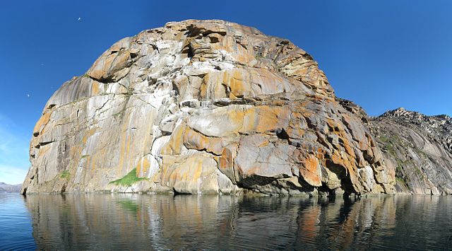
Dansk: Panorama af fuglefjeldet på øen Nunâ øst for Upernavik, syd for Aappilattoq i Grønland. Fotograferet syd for øen under en sejllads til Upernavik Isfjord. På fjeldet, som er 270 m højt yngler måger. De hvide områder på klipperne er efterladenskaber. De orange områder er gødningselskende laver (formentlig Caloplaca og Xanthoria), som er tilpasset de levevilkår det høje næringsindhold fra efterladenskaberne tilbyder. Billedet er som udgangspunkt skabt i programmet Hugin ud fra 17 billeder arrangeret i tre rækker. De enkelte billeder er taget med et håndholdt kamera ( Canon DIGITAL IXUS 800 IS) i en båd der driver lidt med strømmen (for dybt til at kaste anker). Vignetter er søgt fjernet med et tilpasset polynomium i Hugin. Det genererede billede fra Hugin er efterfølgende blevet rektangulært beskåret i GIMP og farveværdikurven er modificeret let for at modvirke overeksponering af visse hvide klippedele. Herefter er billedet Smart Sharpened med en pixel radius på 3,0 og en amount på 30%. Den inverterede kantdetekterede maske er benyttet til at foretage en selektiv Gaussian blur med pixel radius 5.0 i RGB på himlen for at mindske støjen. I det øverste venstre hjørne er "manglende himmel" søgt indsat.
English: Panorama of the island Nunâ east of Upernavik and south of Aappilattoq in Greenland. Photographed south of the island during a sail trip to Upernavik Icefjord. The mountain, which extends 270 m above sea level, is inhabited with gulls. The white areas are bird droppings. The yellow areas are lichen (probably Caloplaca and Xanthoria) adapted to the nutritious environment. The image has been generated using Hugin based on 17 individual photos arranged in three rows. The images were taken with a hand-held camera ( Canon DIGITAL IXUS 800 IS) in a small boat that was slowly drifting (not optimal, but it was too deep to anchor). Vignetting has been minimized using a best fit polynomial in Hugin. The output image from Hugin has been rectangularly cropped in GIMP. The colour value curve has been modified slightly to compensate for over-exposure in certain white areas. Hereafter the photo has been Smart Sharpened with a pixel radius of 3.0 and an amount of 30%. the inverted edge detected mask was used in RGB to apply a selective gaussian blur with pixel radius 5.0 of the sky in an attempt to remove noise there. "Missing sky" in the upper left corner has been pasted in by simple colour picking and painting (do not know other methods).
Français : Vue panoramique de l'île de Nûna à l'est de Upernavik et au sud d'Aappilattoq, au Groenland. Image prise au sud de l'île durant un voyage en voilier vers le Fjord d'Upernavik. La montagne, culminant à 270m, est peuplée de goélands. Les zones blanches sont des fientes d'oiseaux, les taches jaunes, du lichen. Image générée en utilisant Hugin, à partir de 17 photos en 3 rangs. Les photos ont été prises d'une barque à la dérive (l'eau était trop profonde pour mouiller l'ancre). Divers traitements (recadrage, courbes, nettetée, supression du vignetage du ciel) ont été appliqués en utilisant les logiciels Hugin et GIMP.
|
|||
|---|---|---|---|---|
| Source |
Own work in Hugin and GIMP based on own photographs. |
|||
| Date |
2007-08-09 |
|||
| Author |
Kim Hansen |
|||
| Permission ( Reusing this image) |
see below |
|||
| Other versions |
|


| Camera location |
72°45′55.9″N, 55°29′53.7″W |
This and other geocoded Commons images: |
( Info) |
|---|
|
|
This file was a candidate on Picture of the Year 2007. This is a featured picture on Wikimedia Commons: it is considered one of our finest images. If you have an image of similar quality that can be published under a suitable copyright license, be sure to upload it, tag it, and nominate it. |
|
| |
This image was selected as a picture of the day for October 28, 2007. It was captioned as followed: English: Panorama of the island Nunâ in Greenland.
Asturianu: Panorama de la islla Nunâ, en Groenlandia.
Беларуская: Востраў Нуна, Грэнландыя.
Česky: Ostov Nunâ u pobřeží Grónska
Dansk: Panorama af fuglefjeldet på øen Nunâ øst for Upernavik i Grønland.
Deutsch: Panorama der Insel Nuna vor der Küste Grönlands
English: Panorama of the island Nunâ in Greenland.
Español: Vista de la isla de Nunâ, en Groenlandia.
Français : Vue panoramique de l'île de Nûna à l'est de Upernavik et au sud d'Aappilattoq, au Groenland.
Magyar: Panoráma a grönlandi Nunâ szigetről
Íslenska: Eyjan Nunâ á Grænlandi.
Italiano: Vista dell'isola Nunâ in Groenlandia.
日本語: グリーンランドNunâ島の全景。
Latina: Despectus in insulam Nunâ, Groenlandiae
Nederlands: Panorama van het eiland Nunâ ten zuiden van het dorp Aappilattoq voor de kust van de Groenlandse gemeente Upernavik
Polski: Pejzaż wyspy Nunâ ( Grenlandia).
Português: Panorama da ilha Nunâ na Groenlândia.
Русский: Панорама острова Нунья (Упернавик, Гренландия)
Slovenčina: Panoráma ostrova Nunâ pri pobreží Grónska.
Српски / Srpski: Панорама острва Нуна код Гренланда.
Svenska: Ön Nunâ öster om Upernavik vid Grönlands kust.
中文(简体): 格陵兰西部的努纳岛
中文(繁體): 格陵蘭西部的努納島
|
 |
This image has been assessed using the Quality image guidelines and is considered a Quality image. |
Licensing
|

Reference
Det Grønne Grønland, Tyge W. Böcher, Ed. by Bent Fredskild and Jens J. Böcher, Rhodos (2000), ISBN 87 7245 845 3, p. 76-77.
File history
Click on a date/time to view the file as it appeared at that time.
| Date/Time | Dimensions | User | Comment | |
|---|---|---|---|---|
| current | 16:48, 19 August 2007 | 5,249×2,914 (4.64 MB) | Slaunger | ({{Information |Description= {{da|Panorama af fuglefjeldet på øen Nunâ øst for Upernavik, syd for Aappilattoq i Grønland. Fotograferet syd for øen under en sejllads til Upernavik Is) |