Image:Washington DC Panorama.jpg
From Wikipedia, the free encyclopedia
Size of this preview: 640 × 269 pixels
Full resolution (3,008 × 1,262 pixels, file size: 1.65 MB, MIME type: image/jpeg)
| |
This is a file from the Wikimedia Commons. The description on its description page there is shown below. |
Summary
| Description |
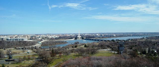
English: View on Washington DC from Arlington, Va, from so called "Top of the Town". Some of the visible landmarks: Iwo Jima Memorial aka Marines War Memorial (bottom left), Theodore Roosevelt Bridge (bridge on the left), Theodore Roosevelt Island, John F. Kennedy Centre for the Performing Arts (across the river on the left from the bridge), Watergate complex (on the left from Kennedy Centre), Washington Monument (centre), Lincoln Memorial (directly in front of Washington Monument), Arlington Memorial Bridge (bridge on the right), Tidal Basin (above the bridge), Thomas Jefferson Memorial (to the right of the Basin), 14th Street Bridge (far right bridge), Netherlands Carillon (black tower up-close on the Virginia side), and Arlington Cemetery.
Polski: Widok na Waszyngton z za rzeki z Arlington w stanie Wirginia. Niektore z widocznych objektów: Iwo Jima Memorial (Pomnik Korpusu Piechoty Morskiej po lewej na dole), Most Teodora Roosevelta (most po lewej), Wyspa Teodora Roosevelta, Teatr Johna F. Kennedy (po drugiej stronie rzeki po lewej od mostu), apartamenty Watergate (po lewej od Teatru Kennedy), Pomnik Waszyngtona (po środku), Pomnik Lincolna (przed Pomnikiem Waszyngtona u jego podstawy), Most Arlington Memorial (most po prawej), Pomnik Tomasza Jeffersona (biały okrągły budynek "ponad" mostem), Most 14-stej Ulicy (skrajny po prawej), Holenderska Dzwonnica (czarna wieża z przodu po prawej stronie), i Narodowy Cmentarz w Arlington.
|
|||||
|---|---|---|---|---|---|---|
| Source |
self-made |
|||||
| Date |
March 14 2008 |
|||||
| Author |
Jarek Tuszynski (aka Jarekt) |
|||||
| Permission ( Reusing this image) |
see below |
|||||
| Other versions |
Pictures from the same location and time
|


| Camera location |
|
See this image at its location on Google Maps This location on: Live Maps - Trails.com - TerraServer-USA |
|---|
Licensing
|

File history
Click on a date/time to view the file as it appeared at that time.
| Date/Time | Dimensions | User | Comment | |
|---|---|---|---|---|
| current | 02:56, 24 April 2008 | 3,008×1,262 (1.65 MB) | Jarekt | (== Summary == {{Information |Description={{en|View on Washington DC from Arlington, Va}} |Source=self-made |Date=2008 |Author= Jarek Tuszynski (aka Jarekt) |Permission= |other_versions= }} {{location dec|38.88921652656352|-77.07265913486481) |
File links
Metadata
This file contains additional information, probably added from the digital camera or scanner used to create or digitize it. If the file has been modified from its original state, some details may not fully reflect the modified file.
| Camera manufacturer | NIKON CORPORATION |
|---|---|
| Camera model | NIKON D40 |
| Exposure time | 1/320 sec (0.003125) |
| F-number | f/9 |
| Date and time of data generation | 14:09, 14 March 2007 |
| Lens focal length | 18 mm |
| Software used | Ver.1.00 |
| File change date and time | 14:09, 14 March 2007 |
| Y and C positioning | 2 |
| Exposure Program | Not defined |
| ISO speed rating | 200 |
| Exif version | 2.21 |
| Date and time of digitizing | 14:09, 14 March 2007 |
| Image compression mode | 4 |
| Exposure bias | 0 |
| Maximum land aperture | 3.6 |
| Metering mode | Pattern |
| Light source | Unknown |
| Flash | 0 |
| DateTime subseconds | 40 |
| DateTimeOriginal subseconds | 40 |
| DateTimeDigitized subseconds | 40 |
| Colour space | sRGB |
| Sensing method | One-chip colour area sensor |
| Custom image processing | Normal process |
| Exposure mode | Auto exposure |
| White balance | Auto white balance |
| Digital zoom ratio | 1 |
| Focal length in 35 mm film | 27 |
| Scene capture type | Standard |
| Contrast | Normal |
| Saturation | Normal |
| Sharpness | Normal |
| Subject distance range | Unknown |