Image:Map Denmark CIA extended.gif
From Wikipedia, the free encyclopedia
No higher resolution available.
Map_Denmark_CIA_extended.gif (300 × 350 pixels, file size: 16 KB, MIME type: image/gif)
| |
This is a file from the Wikimedia Commons. The description on its description page there is shown below. |
Summary
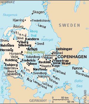
| Description |
Map of Denmark, showing largest cities and island/region names. Most city names (31) have been labeled with font-face Arial or Arial Narrow, as font-size 8 or 10; the island/region names are labeled on the diagonal at a 20-degree slant. Denmark contains over 300 towns, but they are evenly dispersed around 35 main towns, except near Copenhagen, which has very high density. |
|---|---|
| Source |
Derivative of CIA map (Wikimedia Commons): Image:Denmark-CIA WFB Map.png (adding 25 labels, restoring colour to CIA hues, and magnified 15%) |
| Date |
29-August-2007 |
| Author |
Wikid77 (derivative of CIA map, adding 25 labels) |
| Permission ( Reusing this image) |
(see below) |
| Other versions |
This map has some variations:
|
Licensing
 |
This image is in the public domain because it contains materials that originally came from the United States Central Intelligence Agency's World Factbook. Deutsch | English | Español | Français | 日本語 | Nederlands | 한국어 | Português | தமிழ் | Magyar | +/- |
 |
Format

This file is purposely maintained in GIF format (most international GIF-related patents have expired) for compatibility with the original CIA maps. Semi-automatic conversions to PNG-format might lose the colour hues of the CIA maps, tending to shift to lighter blue and shift beige to white. A larger, detailed version of the map is being expanded, with more of the smaller 300 towns added.
File history
Click on a date/time to view the file as it appeared at that time.
| Date/Time | Dimensions | User | Comment | |
|---|---|---|---|---|
| current | 13:51, 4 September 2007 | 300×350 (16 KB) | Wikid77 | (relabeled "NORWAY"/"POLAND"; raised "Taastrup"/"Koge" near city-dots) |
| 15:41, 3 September 2007 | 300×350 (16 KB) | Wikid77 | (added "Kalundborg" by lowering "Fredericia"/"Odense"/"Fyn" and lowered Copenhagen star, "Taastrup"/"Koge" and "Greve Strand" etc.) | |
| 13:24, 31 August 2007 | 300×350 (16 KB) | Wikid77 | (slashed 'o' 3x) | |
| 06:04, 29 August 2007 | 300×350 (16 KB) | Wikid77 | ({{Information | Description=Map of Denmark, showing largest cities and island/region names. | Source=Derivative of CIA map | Date=29-August-2007 | Author= Wikid77 (derivative of CIA map) | Permission=(see below) }} ) |