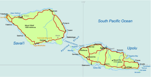
Image:Samoa Country map.png
From Wikipedia, the free encyclopedia
Size of this preview: 640 × 329 pixels
Full resolution (800 × 411 pixels, file size: 132 KB, MIME type: image/png)
| |
This is a file from the Wikimedia Commons. The description on its description page there is shown below. |
| Description |
Map by -- CloudSurfer 11:58, 22 Oct 2004 (UTC) |
|---|---|
| Source |
Originally from en.wikipedia; description page is/was here. |
| Date |
2004-10-22 (original upload date) |
| Author |
Original uploader was CloudSurfer at en.wikipedia |
| Permission ( Reusing this image) |
Released under the GNU Free Documentation License.
|
License information
 |
Permission is granted to copy, distribute and/or modify this document under the terms of the GNU Free Documentation License, Version 1.2 or any later version published by the Free Software Foundation; with no Invariant Sections, no Front-Cover Texts, and no Back-Cover Texts. Subject to disclaimers. Asturianu | Български | Català | Deutsch | English | Español | Français | Gaeilge | Italiano | Polski | Português | +/- |
Original upload log
(All user names refer to en.wikipedia)
- 2004-10-22 11:57 CloudSurfer 3342×1716×8 (487775 bytes) New map
File history
Click on a date/time to view the file as it appeared at that time.
| Date/Time | Dimensions | User | Comment | |
|---|---|---|---|---|
| current | 00:59, 15 June 2007 | 800×411 (132 KB) | Matanya | ({{Information |Description=Map by -- CloudSurfer 11:58, 22 Oct 2004 (UTC) |Source=Originally from [http://en.wikipedia.org en.wikipedia]; description page is/was [http://en.wikipedia.org/w/index.php?title=Image%3ASamoa_Country_map.) |
File links
The following pages on Schools Wikipedia link to this image (list may be incomplete):