Image:Christmas island 76.jpg
From Wikipedia, the free encyclopedia
Size of this preview: 520 × 480 pixels
Full resolution (839 × 774 pixels, file size: 128 KB, MIME type: image/jpeg)
| |
This is a file from the Wikimedia Commons. The description on its description page there is shown below. |
Summary
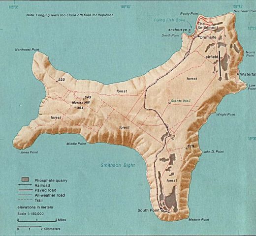
Map of Christmas. This map was produced by the U.S. Central Intelligence Agency, unless otherwise indicated. Maps dated 1976 were taken from The Indian Ocean Atlas, published by the Central Intelligence Agency.
Licensing
 |
This image is a work of a Central Intelligence Agency employee, taken or made during the course of the person's official duties. As a Work of the United States Government, all images created or made by the CIA are in the public domain, with the exception of classified information. |  |
File history
Click on a date/time to view the file as it appeared at that time.
| Date/Time | Dimensions | User | Comment | |
|---|---|---|---|---|
| current | 19:15, 11 February 2006 | 839×774 (128 KB) | Walden69 | (Map of Christmas. This map were produced by the U.S. Central Intelligence Agency, unless otherwise indicated. Maps dated 1976 were taken from The Indian Ocean Atlas, published by the Central Intelligence Agency. {{PD-USGov-CIA}} ) |
File links
The following pages on Schools Wikipedia link to this image (list may be incomplete):
Categories: Maps of Christmas Island