Image:Ming foreign relations 1580.jpg
From Wikipedia, the free encyclopedia
Size of this preview: 409 × 479 pixels
Full resolution (555 × 650 pixels, file size: 321 KB, MIME type: image/jpeg)
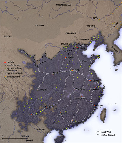
This map shows Ming Dynasty China in 1580. The distribution of guard commanders reflects the dynasty's concern with the north border, the Wokou threat on the eastern seaboard, and also the continuing instability in the southwest.
The imperial courier routes shown are based on Map 2 in Timothy Brook, The Confusions of Pleasure: Commerce and Culture in Ming China. (Berkeley: University of California, 1998), p. 36. Compare with the communication routes of the early empire. (See Image:Han foreign relations CE 2.jpg)
Licensing
| |
I, the creator of this work, hereby grant the permission to copy, distribute and/or modify this document under the terms of the GNU Free Documentation License, Version 1.2 or any later version published by the Free Software Foundation; with no Invariant Sections, no Front-Cover Texts, and no Back-Cover Texts. Subject to disclaimers. |
|
|
The Wikimedia Commons has another file with the same name as this file. To include the Commons media file in Wikipedia, this locally stored file needs to be renamed. | |
File history
Click on a date/time to view the file as it appeared at that time.
| Date/Time | Dimensions | User | Comment | |
|---|---|---|---|---|
| current | 17:35, 25 August 2007 | 555×650 (321 KB) | Gantuya eng ( Talk | contribs) | (Corrected name of Khalha) |
| revert | 17:32, 25 August 2007 | 555×650 (321 KB) | Gantuya eng ( Talk | contribs) | (I corrected the name of Khalha) |
| revert | 03:26, 8 October 2005 | 555×650 (319 KB) | Yeu Ninje ( Talk | contribs) |
See the setup instructions for more information.
File links
Metadata
This file contains additional information, probably added from the digital camera or scanner used to create or digitize it. If the file has been modified from its original state, some details may not fully reflect the modified file.
| Orientation | Normal |
|---|---|
| Horizontal resolution | 150 dpi |
| Vertical resolution | 150 dpi |
| Software used | Adobe Photoshop CS Windows |
| File change date and time | 01:24, 26 August 2007 |
| Colour space | sRGB |