Image:OttomanEmpireIn1683.png
From Wikipedia, the free encyclopedia
Size of this preview: 510 × 480 pixels
Full resolution (1,966 × 1,850 pixels, file size: 327 KB, MIME type: image/png)
| |
This is a file from the Wikimedia Commons. The description on its description page there is shown below. |
| Description |
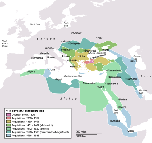
Map depicting the Ottoman Empire at its greatest extent, in 1683. |
|||
|---|---|---|---|---|
| Source |
Self drawn, mainly based on Robert Mantran (ed.), Histoire de l'Empire Ottoman, Paris: Fayard (1989), also en:List of Ottoman Empire dominated territories, Image:Ottoman 1683.png, , and . Background map modified from Image:A large blank world map with oceans marked in blue.svg. |
|||
| Date |
December 21, 2006 |
|||
| Author |
Atilim Gunes Baydin |
|||
| Permission ( Reusing this image) |
Permission is given for anyone to use this for any possible purpose. |
|||
| Other versions |
|


Licensing
 |
I, the copyright holder of this work, hereby release it into the public domain. This applies worldwide. In case this is not legally possible: Afrikaans | Alemannisch | Aragonés | العربية | Asturianu | Български | Català | Cebuano | Česky | Cymraeg | Dansk | Deutsch | Eʋegbe | Ελληνικά | English | Español | Esperanto | Euskara | Estremeñu | فارسی | Français | Galego | 한국어 | हिन्दी | Hrvatski | Ido | Bahasa Indonesia | Íslenska | Italiano | עברית | Kurdî / كوردی | Latina | Lietuvių | Latviešu | Magyar | Македонски | Bahasa Melayu | Nederlands | Norsk (bokmål) | Norsk (nynorsk) | 日本語 | Polski | Português | Ripoarisch | Română | Русский | Shqip | Slovenčina | Slovenščina | Српски / Srpski | Suomi | Svenska | ไทย | Tagalog | Türkçe | Українська | Tiếng Việt | Walon | 中文(简体) | 中文(繁體) | zh-yue-hant | +/- |
File history
Click on a date/time to view the file as it appeared at that time.
| Date/Time | Dimensions | User | Comment | |
|---|---|---|---|---|
| current | 15:12, 26 March 2007 | 1,966×1,850 (327 KB) | AtilimGunesBaydin | (Updated Ionian Islands.) |
| 01:25, 15 March 2007 | 1,966×1,850 (303 KB) | Stevanb | (Corrected some error. Very important (historical) Ottoman "city" in Balkan area is Prizren - on the map marked as Kosovo. Kosovo is region, Prizren is town (Ottoman "city").) | |
| 16:28, 25 February 2007 | 1,966×1,850 (327 KB) | AtilimGunesBaydin | (Minor update.) | |
| 02:34, 18 February 2007 | 1,966×1,850 (327 KB) | AtilimGunesBaydin | (Update territories, some city locations and labels.) | |
| 23:50, 14 February 2007 | 1,940×1,500 (306 KB) | AtilimGunesBaydin | (Minor fixes, updated some borders and the colour scheme.) | |
| 00:55, 23 December 2006 | 1,684×1,348 (283 KB) | AtilimGunesBaydin | (Added more labels.) | |
| 17:47, 21 December 2006 | 1,684×1,347 (244 KB) | AtilimGunesBaydin | ({{Information |Description=Map depicting the Ottoman Empire at its greatest extent, in 1683. |Source=Self drawn, based on information mainly compiled from Image:Ottoman 1683.png, [http://fs.huntingdon.edu/jlewis/Syl/IRcomp/Maps) |