Image:Carte TGV.svg
From Wikipedia, the free encyclopedia
Carte_TGV.svg (SVG file, nominally 1,000 × 1,056 pixels, file size: 990 KB)
| |
This is a file from the Wikimedia Commons. The description on its description page there is shown below. |
Contents |
Summary
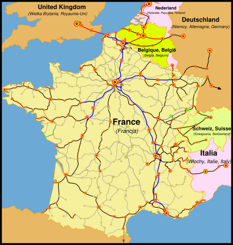
(de) Karte der französischen Eisenbahn (SNCF) mit TGV Hochgeschwindigkeitsnetz
(en) The map of French railways (SNCF) passengers service, including international TGV high-speed trains.
(fr) La carte du réseau voyageurs de la SNCF, les TGV internationaux inclus.
(pl) Mapa sieci połączeń pasażerskich kolei francuskich (SNCF), uwzlędniająca międzynarodowe połączenia pociągami TGV.
(sk) Mapa tratí francúzskych železníc (SNCF) s prepravou cestujúcich a medzinárodných spojení TGV.
(de) Legende
- Eisenbahnlinien:
- blau - Hochgeschwindigkeitsstrecken in Frankreich,
- rot - Hochgeschwindigkeitsstrecken außerhalb Frankreichs,
- schwarz - Klassische Bahnlinien mit TGV-Nutzung,
- rot und blau gepunktet - Hochgeschwindigkeitsstrecken in Bau,
- schwarz gepunktet - Klassische Bahnlinien mit TGV-Nutzung in Planung,
- grau - andere klassische Bahnlinien im Passagierverkehr
- Bahnhöfe und Städte:
- rot:
- Punkte - mit TGV Anbindung,
- Quadrate - ausschließlich TGV Anbindung
- grün:
- Punkte - mit zukünftiger TGV Anbindung,
- Quadrate - mit zukünftiger, ausschließlicher TGV Anbindung,
- Graue Punkte - andere Personenbahnhöfe,
- rot:
- Die Größe der Punkte spiegelt die Größe der Städte wieder.
(es) Leyenda
- Lineas Ferroviarias:
- Azul- Lineas de alta velocidad (LGV) en Francia.
- Rojo- Lineas de alta velocidad exteriores a Francia.
- Negro- Lineas ferroviarias "clasicas" con servicio TGV.
- Azul y Rojo punteados- Lineas de alta velocidad en construcción.
- Negro punteado- Lineas "clasicas" con servicio TGV planeadas para un futuro cercano.
- Gris- Otras lineas ferroviarias "clasicas" con servicio de pasajeros.
- Estaciones Ferroviarias o Ciudades:
- Rojo:
- Puntos- Con servicio TGV
- Cuadrados- Con servicio TGV solamente (Estaciones en LGV)
- Verde:
-
- Puntos- Con servicio TGV en un futuro cercano.
- Cuadrados- Con servicio TGV solamente (Estaciones en LGV). En construcción.
-
- Puntos Grises- Con otros servicios de pasajeros; los tamaños del punto indican los tamaños de la ciudad (arbitrarios).
- Rojo:
(en) Legend
- Railway lines:
- blue - high-speed (LGV) lines in France,
- red - high-speed lines outside France,
- black - 'classic' railway lines with TGV service,
- dashed red and blue - high-speed lines in construction,
- dashed black - 'classic' lines with TGV service planned in near future,
- grey - other 'classic' railway lines with passenger service.
- Railway stations or cities:
- red:
- dots - with TGV service,
- squares - with TGV service only (stations on LGV)
- green:
- dots - with TGV service in near future,
- squares with TGV service only (stations on LGV) in construction,
- grey dots - with other passenger service,
- red:
- dot sizes indicate town sizes (arbitrary).
(fr) Légende
- Lignes ferroviaires:
- bleus - lignes à grande vitesse (LGV) en France,
- rouges - lignes à grande vitesse au dehors de la France,
- noires - lignes 'classiques' avec le service TGV,
- rouges et bleues entrecoupées - lignes à grande vitesse en construction,
- noires entrecoupées - lignes 'classiques' dont le service TGV est prévu,
- grises - autres lignes 'classiques' du réseau voyageurs.
- Gares ferroviaires ou villes:
- rouges:
- points - avec le service TGV,
- carreaux - avec le service TGV uniquement (gares sur les lignes nouvelles)
- verts:
- points - dont le service TGV est prévu,
- carreaux - pour les TGV uniquement (gares sur les lignes nouvelles, en construction),
- points gris - les autres stations ou villes du réseau voyageurs.
- rouges:
- les tailles des points indiquent les grandeurs des villes (subjective)
(pl) Legenda
- Linie kolejowe:
- niebieskie - linie wysokich prędkości (LGV) we Francji,
- czerwone - linie wysokich prędkości poza Francją,
- czarne - linie "klasyczne", po których kursują pociągi TGV,
- czerwone i niebieskie przerywane - linie wysokich prędkości w budowie,
- czarne przerywane - linie 'klasyczne' po który pociągi TGV będą kursować w niedalekiej przyszłości,
- szare - pozostałe linie "klasyczne", po których kursują pociągi pasażerskie.
- Dworce kolejowe lub miasta:
- czerwone:
- punkty - na których zatrzymują się pociągi TGV,
- kwadraty - na których zatrzymują się wyłącznie pociągi TGV (dworce na liniach wysokich prędkości),
- zielone:
- punkty - do których pociągi TGV dotrą w niedalekiej przyszłości,
- kwadraty - dworce w budowie, przeznaczone wyłącznie dla pociągów TGV,
- szare punkty - pozostałe dworce kolejowe na liniach "kalsycznych".
- czerwone:
- wielkość punktów wskazuje wielkość stacji lub miasta (subiektywnie).
(sk) Vysvetlivky
- Železničné trate:
- modrá - vysokorýchlostné trate (LGV) vo Francúzsku,
- červená - vysokorýchlostné trate mimo Francúzska,
- čierna - štandardné trate s prevádzkou TGV,
- prerušovaná červeno-modrá - vysokorýchlostné trate vo výstavbe,
- prerušovaná čierna - štandardné trate s prevádzkou TGV plánovanou v blízkej budúcnosti,
- šedá - ďalšie štandardné trate s prepravou cestujúcich.
- Železničné stanice alebo mestá:
- červená:
- body - s prevádzkou TGV ,
- štvorce - len s prevádzkou TGV (stanice na LGV)
- zelené:
- body - s prevádzkou TGV plánovanou v blízkej budúcnosti,
- štvorce - len s prevádzkou TGV (stanice na LGV) vo výstavbe,
- šedé body - s ostatnou prepravou cestujúcich
- červená:
Veľkosť bodov znamená veľkosť miest (orientačne).
(en) Own work, author: madcap. Map based on SNCF map published on its web site.
(fr) Auteur de la carte: madcap. Travail basé sur la carte du reséau publié par la SNCF sur sa site interner.
(pl) Autor mapy: madcap. Praca oparta na mapie opublikowanej na stronie internetowej firmy SNCF.
(sk) Autor mapy: madcap Mapa je vytvorené na základe mapy SNCF publikovanej na tejto web stránke.
Licensing
 |
Permission is granted to copy, distribute and/or modify this document under the terms of the GNU Free Documentation license, Version 1.2 or any later version published by the Free Software Foundation; with no Invariant Sections, no Front-Cover Texts, and no Back-Cover Texts. A copy of the license is included in the section entitled " GNU Free Documentation license". Aragonés | العربية | Asturianu | Беларуская (тарашкевіца) | Български | বাংলা | ইমার ঠার/বিষ্ণুপ্রিয়া মণিপুরী | Brezhoneg | Bosanski | Català | Cebuano | Česky | Dansk | Deutsch | Ελληνικά | English | Esperanto | Español | Eesti | Euskara | فارسی | Suomi | Français | Gaeilge | Galego | עברית | Hrvatski | Magyar | Bahasa Indonesia | Ido | Íslenska | Italiano | 日本語 | ქართული | ភាសាខ្មែរ | 한국어 | Kurdî / كوردی | Latina | Lëtzebuergesch | Lietuvių | Bahasa Melayu | Nnapulitano | Nederlands | Norsk (nynorsk) | Norsk (bokmål) | Occitan | Polski | Português | Română | Русский | Slovenčina | Slovenščina | Shqip | Српски / Srpski | Svenska | తెలుగు | ไทย | Tagalog | Türkçe | Українська | اردو | Tiếng Việt | Volapük | Yorùbá | 中文(简体) | 中文(繁體) | +/- |
File history
Click on a date/time to view the file as it appeared at that time.
| Date/Time | Dimensions | User | Comment | |
|---|---|---|---|---|
| current | 22:13, 24 March 2008 | 1,000×1,056 (990 KB) | Madcap | (Maybe this time it will work...) |
| 00:46, 24 March 2008 | 1,000×1,056 (990 KB) | Madcap | (Reverted to version as of 00:40, 24 March 2008) | |
| 00:45, 24 March 2008 | 1,000×1,056 (990 KB) | Madcap | (Old version mistakenly uploaded) | |
| 00:40, 24 March 2008 | 1,000×1,056 (990 KB) | Madcap | ((pl) Liczne poprawki mapki: * Zmiana kolorow * Linia High Speed 1 (Wielka Wrytania): ** drugi odcinek linii otwarty, ** dodano dwa dworce: Stratford International (jescze nie obslugiwany, zaznaczony jako "w budowie") oraz Ebbsfleet International (obecnie ) | |
| 07:48, 19 June 2007 | 1,000×1,056 (977 KB) | Andrew pmk | (update map to show that LGV Est is now open; correct spelling error ) | |
| 23:11, 9 June 2007 | 1,000×1,056 (1,004 KB) | PemFR | ({{French TGV network map |Description= |Source= |Date= |Author= |Permission= |other_versions= }}) | |
| 22:37, 9 June 2007 | 1,000×1,056 (1,004 KB) | PemFR | ({{Information |Description=French TGV network map |Source= |Date= |Author= |Permission= |other_versions= }}) | |
| 12:57, 17 September 2006 | 1,000×1,056 (1,004 KB) | Steff | (== Summary == (en) The map of French railways (SNCF) passengers service, including internationnal TGV high-speed trains.<br> (fr) La carte du réseau voyageurs de la SNCF, les TGV internationaux inclus.<br> (pl) Mapa sieci połączeń pasażerskich kolei ) | |
| 05:53, 24 March 2006 | 1,000×1,056 (1.01 MB) | Madcap | ((en) The map of French railways (SNCF) passengers service, including internationnal TGV high-speed trains.<br> (fr) La carte du réseau voyageurs de la SNCF, les TGV internationaux inclus.<br> (pl) Mapa sieci połączeń pasażerskich kolei francuskich (S) |