Image:Panama Canal Rough Diagram.png
From Wikipedia, the free encyclopedia
Size of this preview: 497 × 479 pixels
Full resolution (670 × 646 pixels, file size: 264 KB, MIME type: image/png)
| |
This is a file from the Wikimedia Commons. The description on its description page there is shown below. |
Summary
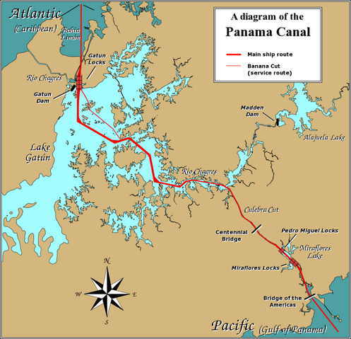
A diagram illustrating the layout of the Panama Canal.
Due to the shape of the Isthmus of Panama, the Pacific end of the canal is actually the south-east end, and the Caribbean / Atlantic end is at the north-west. From the Pacific side, the Miraflores and Pedro Miguel locks (with two and one stages respectively) lead up to the highest level of the canal, 26 metres (85 feet) above sea level. The Culebra Cut (or Gaillard Cut) leads to Gatún Lake, created by damming the Chagres River; then the Gatún Locks lead back down to sea level in Limón Bay.
The heavy red line shows the ship route. The narrower red line in Gatún Lake is the Banana Cut, a shortcut used by canal boats and yachts.
Licensing
|

File history
Click on a date/time to view the file as it appeared at that time.
| Date/Time | Dimensions | User | Comment | |
|---|---|---|---|---|
| current | 14:14, 23 November 2005 | 670×646 (264 KB) | Johantheghost | (New version with more detail, plus the dams) |
| 20:30, 9 November 2005 | 887×672 (127 KB) | Johantheghost | (Better captions.) | |
| 19:44, 5 October 2005 | 887×672 (109 KB) | Johantheghost | ||
| 19:51, 3 October 2005 | 887×672 (104 KB) | Johantheghost | (A diagram illustrating the layout of the Panama Canal.) |