Image:Attila in Gaul 451CE.svg
From Wikipedia, the free encyclopedia
Attila_in_Gaul_451CE.svg (SVG file, nominally 1,283 × 981 pixels, file size: 510 KB)
| |
This is a file from the Wikimedia Commons. The description on its description page there is shown below. |
| Description |
Deutsch: Dies ist die deutschsprachige Diagrammversion, andere sind unten angegeben.
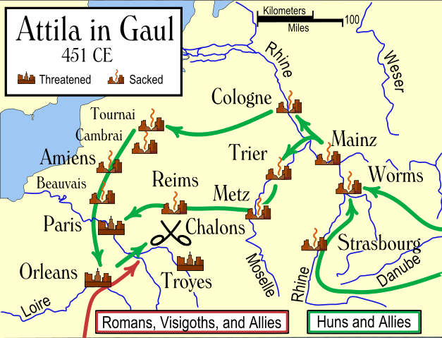
Das Diagramm zeigt die wahrscheinlichen Wege, die von den Hunnen bei ihrer Invasion Galliens 451 benutzt wurden, und die Schicksale der Städte auf ihrem Weg. Die verschiedenen Quellen ergeben widersprüchliche Information darüber, ob Städte geplündert wurden, inbesondere Trier. Es wird auch gesagt, daß einige Städte südöstlich von Troyes einschließlich Auxerre, Besancon und Langres geplündert wurden. English: An historical map showing the Hun invasion of Gaul in 451 CE (AD), leading to the Battle of Chalons. The generally accepted routes are shown, along with the larger cities threatened or sacked by the Huns.
Français : Une carte historique montrant l'invasion des Huns de la Gaule en 451 Ap J-C, et la bataille des champs Catalauniques. Les itinéraires probables sont montrés, avec les villes plus grandes menacées ou pillées par les huns.
Italiano: Carta storica che descrive l'invasione della Gallia da parte degli Unni nel 451 d.C., e la battaglia dei Campi Catalaunici. Sono mostrati i probabili itinerari, e le città conquistate o risparmiate dagli Unni.
|
||||
|---|---|---|---|---|---|
| Source |
own-work |
||||
| Date | |||||
| Author | |||||
| Permission ( Reusing this image) |
|
||||
| Other versions |
|


References
- Various other sources including the Catholic Encyclopedia articles on the various cities.
Various sources give conflicting information on whether some cities were sacked, in particular Trier. Man says "no", while Ferrill says "yes". Most other sources agree with Ferrill. There are also several cities southeast of Troyes which were said to have been sacked, including Auxerre, Besancon, and Langres.
In order to be as understandable as possible to the average reader, I have used the modern-day names of the towns, rather than the names used in 451 CE.
File history
Click on a date/time to view the file as it appeared at that time.
| Date/Time | Dimensions | User | Comment | |
|---|---|---|---|---|
| current | 17:40, 14 November 2006 | 1,283×981 (510 KB) | MapMaster | (I did it right this time (I hope). The problem is that I don't have a good SVG preview capability.) |
| 17:22, 14 November 2006 | 1,182×948 (510 KB) | MapMaster | (I truly uploaded an improved version this time. Honest) | |
| 17:07, 14 November 2006 | 1,182×948 (167 KB) | MapMaster | (Uploaded an improved version.) | |
| 02:22, 30 October 2006 | 1,292×989 (498 KB) | MapMaster | (An historical map showing the Hun invasion of Gaul in 451 CE (AD), leading to the Battle of Chalons.) |