Image:Huns empire.png
From Wikipedia, the free encyclopedia
Size of this preview: 640 × 366 pixels
Full resolution (998 × 571 pixels, file size: 148 KB, MIME type: image/png)
| |
This is a file from the Wikimedia Commons. The description on its description page there is shown below. |
 |
I, the copyright holder of this work, hereby release it into the public domain. This applies worldwide. In case this is not legally possible, |
Summary
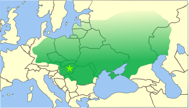
This is a map of the empire of Attila the Hun, circa 450 CE (AD), superimposed on modern borders. The borders of Attila's empire are only approximate because:
- The empire was a very loose collection of conquered peoples and did not have the structure of a formal empire (such as the Roman Empire).
- Records of the eastern and northern borders of Attila's empire are nearly non-existent.
The star shows the approximate location of the capital of Attila's empire. It is not known with any certainty where the capital was actually located. It was either based on the ruins of the Roman city of Acquincum (today's Budapest), or it was his mobile 'wooden castle' (as described by Priscus Rhetor on his visit to Attila's camp), which was based primarily in the Hungarian Great Plain, somewhere near the Tisza River.
Recently, a mysterious massive fortress 20km north of Timisoara, Romania has been put forward as the actual location.
References
- Bjorklund, Oddvar; Holmboe, Haakon; Rohr, Anders (1970) Historical Atlas of the World, Barnes & Noble, NY, SBN: 389-00253-4.
- Man, John, (2006) Attila: The Barbarian King Who Challenged Rome, Thomas Dunne Books, New York.
 |
I, the copyright holder of this work, hereby release it into the public domain. This applies worldwide. In case this is not legally possible: Afrikaans | Alemannisch | Aragonés | العربية | Asturianu | Български | Català | Cebuano | Česky | Cymraeg | Dansk | Deutsch | Eʋegbe | Ελληνικά | English | Español | Esperanto | Euskara | Estremeñu | فارسی | Français | Galego | 한국어 | हिन्दी | Hrvatski | Ido | Bahasa Indonesia | Íslenska | Italiano | עברית | Kurdî / كوردی | Latina | Lietuvių | Latviešu | Magyar | Македонски | Bahasa Melayu | Nederlands | Norsk (bokmål) | Norsk (nynorsk) | 日本語 | Polski | Português | Ripoarisch | Română | Русский | Shqip | Slovenčina | Slovenščina | Српски / Srpski | Suomi | Svenska | ไทย | Tagalog | Türkçe | Українська | Tiếng Việt | Walon | 中文(简体) | 中文(繁體) | zh-yue-hant | +/- |
File history
Click on a date/time to view the file as it appeared at that time.
| Date/Time | Dimensions | User | Comment | |
|---|---|---|---|---|
| current | 12:39, 20 November 2006 | 998×571 (148 KB) | Drat | (Optimised with OptiPNG.) |
| 04:44, 14 November 2006 | 998×571 (186 KB) | MapMaster | (Made some minor modifications after seeing the map "in print") | |
| 04:18, 14 November 2006 | 998×571 (209 KB) | MapMaster | (Improved up this map with a more empire-centered view, quieter colors, and adjusted borders. Created by User:MapMaster ) | |
| 09:23, 30 May 2006 | 752×590 (16 KB) | Drat | (Optimised with OptiPNG.) | |
| 18:54, 7 November 2004 | 752×590 (37 KB) | .:Ajvol:. | (Map of huns empire) |