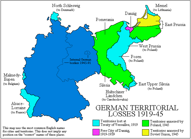
Image:Germanborders.png
From Wikipedia, the free encyclopedia
Size of this preview: 640 × 467 pixels
Full resolution (683 × 498 pixels, file size: 18 KB, MIME type: image/png)
| |
This is a file from the Wikimedia Commons. The description on its description page there is shown below. |
  It is recommended that the other file be used.
Alemannisch | العربية | Български | Česky | Dansk | Deutsch | English | Ελληνικά | Esperanto | Español | Français | Galego | עברית | हिन्दी | Magyar | Bahasa Indonesia | Italiano | 日本語 | 한국어 | Lietuvių | Nederlands | Norsk (nynorsk) | Norsk (bokmål) | Polski | Português | Română | Русский | Slovenščina | Српски / Srpski | Svenska | Türkçe | 中文(简体) | 中文(繁體) | +/- |
 |
This map has been uploaded by Electionworld from en.wikipedia.org to enable the |
Summary
Map created by User:Adam Carr, June 2006
Map converted to PNG from the original GIF by User:GhePeU. GhePeU 11:57, 17 September 2007 (UTC)
Licensing
 |
I, the copyright holder of this work, hereby release it into the public domain. This applies worldwide. In case this is not legally possible: Afrikaans | Alemannisch | Aragonés | العربية | Asturianu | Български | Català | Cebuano | Česky | Cymraeg | Dansk | Deutsch | Eʋegbe | Ελληνικά | English | Español | Esperanto | Euskara | Estremeñu | فارسی | Français | Galego | 한국어 | हिन्दी | Hrvatski | Ido | Bahasa Indonesia | Íslenska | Italiano | עברית | Kurdî / كوردی | Latina | Lietuvių | Latviešu | Magyar | Македонски | Bahasa Melayu | Nederlands | Norsk (bokmål) | Norsk (nynorsk) | 日本語 | Polski | Português | Ripoarisch | Română | Русский | Shqip | Slovenčina | Slovenščina | Српски / Srpski | Suomi | Svenska | ไทย | Tagalog | Türkçe | Українська | Tiếng Việt | Walon | 中文(简体) | 中文(繁體) | zh-yue-hant | +/- |
File history
Click on a date/time to view the file as it appeared at that time.
| Date/Time | Dimensions | User | Comment | |
|---|---|---|---|---|
| current | 14:12, 13 January 2008 | 683×498 (18 KB) | JordiCubero | (Corrections: The Isle of Sylt and Western Upper Silesia stayed with Germany) |
| 11:56, 17 September 2007 | 683×498 (13 KB) | GhePeU | ({{Information |Description= |Source= |Date= |Author= |Permission= |other_versions= }} ) |