Image:Deutsches Reich2.png
From Wikipedia, the free encyclopedia
Size of this preview: 480 × 480 pixels
Full resolution (2,362 × 2,362 pixels, file size: 2.45 MB, MIME type: image/png)
| |
This is a file from the Wikimedia Commons. The description on its description page there is shown below. |
Beschreibung
| Description |
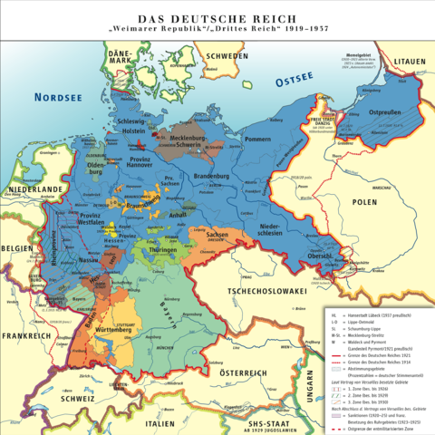
Karte des Deutschen Reiches, »Weimarer Republik/Drittes Reich« 1919–1937 / Map of German Reich, »Republic of Weimar/Third Reich« 1919–1937 |
|---|---|
| Source |
own drawing/Source of Information: Putzger – Historischer Weltatlas, 89. Auflage, 1965 |
| Date |
2006-10-06 |
| Author |
kgberger |
| Permission ( Reusing this image) |
GNU FDL |
| Other versions | DR1919-1937.svg |
 A vector version of this image (SVG) is available. For more information about vector graphics, read about Commons transition to SVG. Deutsch | English | Español | Français | Galego | עברית | Magyar | Italiano | 日本語 | 한국어 | Lietuvių | Polski | Português | Русский | Српски / Srpski | Українська | +/- |
 |
Licensing
|

File history
Click on a date/time to view the file as it appeared at that time.
| Date/Time | Dimensions | User | Comment | |
|---|---|---|---|---|
| current | 12:57, 13 August 2008 | 2,362×2,362 (2.45 MB) | Kgberger | ({{Information |Description= |Source= |Date= |Author= |Permission= |other_versions= }}) |
| 12:42, 4 July 2008 | 2,362×2,362 (2.45 MB) | Kgberger | ({{Information |Description= |Source= |Date= |Author= |Permission= |other_versions= }}) | |
| 15:28, 6 March 2008 | 3,248×3,259 (1.8 MB) | Kgberger | ||
| 13:03, 18 February 2008 | 3,248×3,259 (1.8 MB) | Kgberger | ||
| 12:40, 18 January 2008 | 3,248×3,259 (1.79 MB) | Kgberger | ||
| 15:32, 29 November 2007 | 3,246×3,260 (2.12 MB) | Kgberger | ||
| 14:08, 11 October 2007 | 3,248×3,259 (1.76 MB) | Kgberger | ||
| 12:14, 8 October 2007 | 3,248×3,259 (1.76 MB) | Kgberger | ||
| 15:00, 24 September 2007 | 3,243×3,264 (1.13 MB) | Kgberger | ||
| 12:00, 30 August 2007 | 3,242×3,263 (1.13 MB) | Kgberger | ||
| 11:22, 5 July 2007 | 3,205×3,225 (3.69 MB) | Kgberger | ||
| 14:43, 26 February 2007 | 3,204×3,224 (3.7 MB) | Kgberger | ||
| 13:26, 16 February 2007 | 3,205×3,224 (3.7 MB) | Kgberger | ||
| 11:37, 8 February 2007 | 3,204×3,224 (3.62 MB) | Kgberger | ||
| 13:54, 17 January 2007 | 3,204×3,224 (3.62 MB) | Kgberger | ||
| 14:04, 3 January 2007 | 3,237×3,158 (3.62 MB) | Kgberger | ||
| 15:06, 22 December 2006 | 3,235×3,159 (3.61 MB) | Kgberger | ||
| 13:40, 19 December 2006 | 3,236×3,159 (3.59 MB) | Kgberger | ||
| 14:20, 15 December 2006 | 3,235×3,158 (3.56 MB) | Kgberger | ||
| 11:43, 15 November 2006 | 3,235×3,110 (876 KB) | Kgberger | ||
| 14:27, 10 November 2006 | 777×747 (759 KB) | Kgberger | ||
| 13:57, 9 October 2006 | 3,238×3,113 (4.51 MB) | Kgberger | ||
| 13:47, 9 October 2006 | 3,239×3,113 (4.51 MB) | Kgberger | ||
| 09:14, 9 October 2006 | 3,238×3,112 (4.95 MB) | Piedone | ||
| 14:07, 6 October 2006 | 3,238×3,112 (4.52 MB) | Kgberger | ||
| 11:38, 6 October 2006 | 3,236×3,112 (4.43 MB) | Kgberger | (* Description: Karte des »Deutschen Reiches/Weimarer Republik« 1919–1937 / Map of »German Reich/Republic of Weimar« 1919–1937 * Source of information: Putzger – Historischer Weltatlas, 89. Auflage, 1965 * Author: [[:de:Benutzer:kgberger|kgberger) |